Category:Jansstraat 24, Arnhem
Jump to navigation
Jump to search
| Object location | | View all coordinates using: OpenStreetMap |
|---|
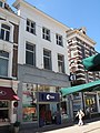
building in Arnhem, Netherlands  | |||||
| Upload media | |||||
| Instance of | |||||
|---|---|---|---|---|---|
| Location | Arnhem, Gelderland, Netherlands | ||||
| Street address |
| ||||
| Located on street | |||||
| Heritage designation |
| ||||
 | |||||
|
This is a category about rijksmonument number 8332
|
| Address |
|
Media in category "Jansstraat 24, Arnhem"
The following 4 files are in this category, out of 4 total.
-
 Arnhem - Jansstraat 24.jpg 1,944 × 2,592; 1.14 MB
-
 Jansstr. 24, voorgevel - Arnhem - 20025400 - RCE.jpg 1,189 × 1,200; 295 KB
-
 Jansstraat 24, overzicht - Arnhem - 20025401 - RCE.jpg 1,200 × 957; 205 KB
-
 Jansstraat 24, overzicht - Arnhem - 20025402 - RCE.jpg 1,200 × 951; 227 KB


