Category:July 2013 in the East Riding of Yorkshire
Jump to navigation
Jump to search
Ceremonial counties of England: Bedfordshire · Berkshire · Buckinghamshire · Cambridgeshire · Cheshire · Cornwall · Cumbria · Derbyshire · Devon · Dorset · East Riding of Yorkshire · East Sussex · Essex · Gloucestershire · Greater London · Greater Manchester · Hampshire · Herefordshire · Hertfordshire · Isle of Wight · Kent · Lancashire · Leicestershire · Lincolnshire · Merseyside · Norfolk · North Yorkshire · Northamptonshire · Northumberland · Nottinghamshire · Oxfordshire · Shropshire · Somerset · South Yorkshire · Staffordshire · Suffolk · Surrey · Tyne and Wear · Warwickshire · West Midlands · West Sussex · West Yorkshire · Wiltshire · Worcestershire
City-counties: Bristol ·
Former historic counties:
Other former counties:
City-counties: Bristol ·
Former historic counties:
Other former counties:
Ok
Deutsch: Bilder, die im Juli 2013 in the East Riding of Yorkshire aufgenommen worden sind. Bitte beachten Sie, dass dies weder das Datum des Uploads noch das Datum des Scannens eines Fotos ist.
English: Images/pictures taken in the East Riding of Yorkshire during July 2013. Note this is not the date of the upload, nor the date a photo was scanned.
Español: Fotografías o imágenes tomadas en the East Riding of Yorkshire durante julio 2013. No es la fecha de subida ni escaneo, sino la fecha en que las fotografías o imágenes se crearon.
Esperanto: Bildoj faritaj en the East Riding of Yorkshire en julio 2013. Tio ne estas la dato, kiam la bildoj estis alŝutitaj aŭ skanitaj.
Français : Photographies ou images prises en the East Riding of Yorkshire durant juillet 2013. Ce n'est pas la date du téléchargement ou du scan.
Galego: Fotografías ou imaxes tomadas en the East Riding of Yorkshire durante xullo 2013. Non é a data de subida nin escaneamento, senón a data na que se crearon as fotografías ou imaxes.
Italiano: Fotografie o immagini scattate a the East Riding of Yorkshire nel luglio 2013. Nota bene: la data non si riferisce né a quella di upload né a quella in cui la foto è stata digitalizzata.
Norsk bokmål: Bilder tatt i the East Riding of Yorkshire i løpet av juli 2013. Merk at dette ikke er datoen for opplasting, eller når et bilde har blitt skannet.
Norsk nynorsk: Bilete teke i the East Riding of Yorkshire i løpet av juli 2013. Merk at dette ikkje er datoen for opplasting, eller når eit bilete har vorte skanna.
Русский: Изображения, сделанные в the East Riding of Yorkshire в течение июль 2013 (не дата загрузки изображения).
Українська: Зображення, зроблені в the East Riding of Yorkshire протягом липень 2013. Зауважте, що це не дата завантаження чи дата сканування фотографії.
| July 2012 | ← | July 2013 | → | July 2014 | |||||||
| Jan | Feb | Mar | Apr | May | Jun | Jul | Aug | Sep | Oct | Nov | Dec |
| 100 | 16 | 30 | 50 | 25 | 53 | 46 | 121 | 55 | 18 | 71 | 37 |
|---|---|---|---|---|---|---|---|---|---|---|---|
Subcategories
This category has only the following subcategory.
- July 2013 in Kingston upon Hull (11 F)
Media in category "July 2013 in the East Riding of Yorkshire"
The following 45 files are in this category, out of 45 total.
-
 Aeriel View of RAF Holmpton.jpg 871 × 579; 88 KB
-
 Beck Bank, Cottingham IMG 5347 - panoramio.jpg 933 × 1,400; 592 KB
-
 Beverley, HU17 (geograph 3554461).jpg 2,811 × 3,640; 2.12 MB
-
 Beverley, HU17 (geograph 3556006).jpg 3,279 × 2,185; 1.24 MB
-
 Bridlington, YO15 (geograph 3557518).jpg 3,401 × 2,559; 1.71 MB
-
 Brind (geograph 3568009).jpg 640 × 427; 71 KB
-
 Brind Lane (geograph 3568001).jpg 640 × 427; 104 KB
-
 Buckton Mill, East Riding-geograph.org-3554421.jpg 3,187 × 2,382; 2.31 MB
-

-

-
 Driffield YO25 (geograph 3557104).jpg 3,638 × 2,724; 2.09 MB
-
 End of Brind Lane (geograph 3567999).jpg 640 × 427; 86 KB
-
 Farm near Brind (geograph 3568012).jpg 640 × 427; 66 KB
-
 Farmland off Brind Lane (geograph 3568004).jpg 640 × 427; 81 KB
-
 Field of Barley (geograph 3567994).jpg 640 × 427; 88 KB
-
 Field with some rape (geograph 3567998).jpg 640 × 427; 78 KB
-
 Float 31, River Humber (geograph 3589569).jpg 1,024 × 768; 106 KB
-
 Footpath near Wressle (geograph 3567987).jpg 640 × 427; 73 KB
-
 High Street Bridlington 1.jpg 3,024 × 4,032; 2.26 MB
-
 House in Brind (geograph 3568011).jpg 640 × 427; 121 KB
-
 House on a junction (geograph 3568749).jpg 640 × 427; 104 KB
-
 House on the junction (geograph 3567988).jpg 640 × 427; 102 KB
-
 Houses in Wressle (geograph 3567989).jpg 640 × 427; 79 KB
-
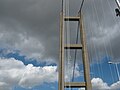 Humber Bridge Tower.JPG 3,648 × 2,736; 1.89 MB
-
 Junction with Wood Lane (geograph 3568019).jpg 640 × 427; 131 KB
-
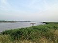 Looking west from the river bank at Faxfleet.JPG 3,264 × 2,448; 2.82 MB
-
 Lower Whitton Float, River Humber (geograph 3589579).jpg 1,024 × 768; 74 KB
-
 Main Street (geograph 3568754).jpg 640 × 427; 85 KB
-
 Market Green, Cottingham IMG 5374 - panoramio.jpg 1,001 × 1,400; 383 KB
-
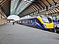 Paragon Station, Anlaby Road, Kingston upon Hull (geograph 3551985).jpg 3,258 × 2,440; 2.53 MB
-
 Pyronia tithonus IMG 5365 - panoramio.jpg 856 × 1,200; 285 KB
-
 Road from Wressle (geograph 3567990).jpg 640 × 427; 87 KB
-
 Road near Grange Plantation (geograph 3567992).jpg 640 × 427; 75 KB
-
 Road to Wressle (geograph 3567997).jpg 640 × 427; 85 KB
-
 Sacred Heart Church (geograph 3568745).jpg 640 × 427; 90 KB
-
 Spurn Lighthouse in the sea mist.JPG 3,552 × 2,583; 1.09 MB
-
 Stamford Bridge Viaduct - geograph.org.uk - 3520180.jpg 640 × 426; 185 KB
-
 Towards Brind Crossing (geograph 3568008).jpg 427 × 640; 82 KB
-
 Towards Drax (geograph 3566740).jpg 640 × 427; 54 KB
-
 Towards Drax (geograph 3568006).jpg 640 × 427; 69 KB
-
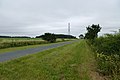
 Towards the Windfarm (geograph 3568751).jpg 640 × 427; 86 KB
-
 West Green, Cottingham IMG 5371 - panoramio.jpg 932 × 1,400; 498 KB
-
 Wheat off Breighton Road (geograph 3566738).jpg 640 × 427; 96 KB
-
 Woodmansey, HU17 (geograph 3553467).jpg 3,312 × 2,519; 1.73 MB
-
 Woodmansey, HU17 (geograph 3553554).jpg 4,032 × 3,024; 2.88 MB


.jpg)
.jpg)
.jpg)
.jpg)
.jpg)


.jpg)
.jpg)
.jpg)
.jpg)
.jpg)
.jpg)
.jpg)
.jpg)

.jpg)
.jpg)
.jpg)
.jpg)

.jpg)

.jpg)
.jpg)

.jpg)

.jpg)
.jpg)
.jpg)
.jpg)


.jpg)
.jpg)
.jpg)
.jpg)

.jpg)
.jpg)
.jpg)