Category:Kallenkote 25, Kallenkote
Jump to navigation
Jump to search
| Object location | | View all coordinates using: OpenStreetMap |
|---|
farmhouse in Steenwijkerland, Netherlands  | |||||
| Upload media | |||||
| Instance of | |||||
|---|---|---|---|---|---|
| Location | Kallenkote, Steenwijkerland, Overijssel, Netherlands | ||||
| Street address |
| ||||
| Located on street |
| ||||
| Heritage designation |
| ||||
 | |||||
|
This is a category about rijksmonument number 46921
|
| Address |
|
Media in category "Kallenkote 25, Kallenkote"
The following 28 files are in this category, out of 28 total.
-
 Hooiberg, staat achter de boerderij - Kallenkote - 20397901 - RCE.jpg 1,200 × 960; 233 KB
-

-
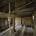
 Interieur, kapconstructie in het stalgedeelte - Kallenkote - 20397912 - RCE.jpg 1,200 × 1,200; 352 KB
-
 Interieur, overzicht van de deel - Kallenkote - 20397910 - RCE.jpg 1,200 × 1,200; 260 KB
-
 Interieur, overzicht van de deel - Kallenkote - 20397914 - RCE.jpg 1,200 × 1,200; 234 KB
-

-
 Interieur, overzicht van het voorhuis - Kallenkote - 20397905 - RCE.jpg 1,200 × 960; 221 KB
-
 Interieur, toegangsdeur - Kallenkote - 20397909 - RCE.jpg 1,200 × 1,200; 174 KB
-

-
 Interieur, zicht op de toegang naar de kelder - Kallenkote - 20397907 - RCE.jpg 1,200 × 1,200; 171 KB
-

-
 Kallenkote 46921 004.jpg 3,738 × 2,376; 956 KB
-
 Overzicht - Kallenkote - 20121518 - RCE.jpg 1,185 × 1,200; 308 KB
-
 Overzicht achterzijde schuur - Kallenkote - 20121521 - RCE.jpg 1,181 × 1,200; 315 KB
-

-
 Overzicht van de stal, rechts van de boerderij - Kallenkote - 20397893 - RCE.jpg 1,200 × 960; 232 KB
-

-

-
 Overzicht van de voorgevel van de boerderij - Kallenkote - 20397897 - RCE.jpg 1,200 × 960; 205 KB
-

-

-

-
 Restant van schuurtje, staat links van de boerderij - Kallenkote - 20397903 - RCE.jpg 1,200 × 1,200; 477 KB
-
 Restant van schuurtje, staat links van de boerderij - Kallenkote - 20397904 - RCE.jpg 1,200 × 1,200; 397 KB
-
 Schuurtje - Kallenkote - 20121522 - RCE.jpg 1,195 × 1,200; 309 KB
-
 Voorgevel - Kallenkote - 20121519 - RCE.jpg 1,198 × 1,200; 408 KB
-

-
 Zijgevel schuur - Kallenkote - 20121520 - RCE.jpg 1,193 × 1,200; 376 KB


