Category:Kammerweiher
Jump to navigation
Jump to search
| Object location | | View all coordinates using: OpenStreetMap |
|---|
Deutsch: Die Kammerweiher sind zwei Gewässer im Naturschutzgebiet Pegnitzau zwischen Ranna und Michelfeld in Bayern.
Subcategories
This category has the following 2 subcategories, out of 2 total.
O
- Oberer Kammerweiher (6 F)
U
- Unterer Kammerweiher (13 F)
Media in category "Kammerweiher"
The following 10 files are in this category, out of 10 total.
-
 2019 Kammerweiher Tafel.jpg 3,697 × 5,461; 3.37 MB
-
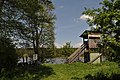
 Bad im kammerweiher.jpg 4,608 × 3,456; 6.05 MB
-
 Kammerweiher 3.jpg 4,288 × 2,848; 6.21 MB
-
 Kammerweiher1.jpg 3,456 × 5,184; 6.44 MB
-
 Kammerweiher2.jpg 3,264 × 1,836; 1.39 MB
-
 Kanadagans beim Kammerweiher.jpg 4,608 × 3,456; 5.98 MB
-
 Kanadagänse1.jpg 5,208 × 3,476; 7.51 MB
-
 Kanadagänse2.jpg 5,208 × 3,476; 10.45 MB
-
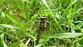 Libelle Kammerweiher.jpg 4,320 × 2,432; 2.79 MB
-
 Schwan im Kammerweiher.jpg 4,096 × 3,072; 7.16 MB


Categories:
- Lakes of Upper Palatinate
- Naturschutzgebiet Pegnitzau zwischen Ranna und Michelfeld
- Landschaftsschutzgebiet innerhalb des Naturparks Fränkische Schweiz - Veldensteiner Forst (ehemals Schutzzone)
- Pegnitz (Regnitz)
- Geography in Auerbach in der Oberpfalz
- Bodies of water in Naturpark Fränkische Schweiz-Veldensteiner Forst