Category:Kappadozia 6 (Schwabach)
Jump to navigation
Jump to search
| Object location | | View all coordinates using: OpenStreetMap |
|---|
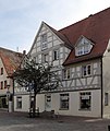
This is the category of the Bavarian Baudenkmal (cultural heritage monument) with the ID D-5-65-000-70 (Wikidata)
|
Deutsch: Schwabach - Kappadozia 6 - Wohnhaus. Traufseitbau mit Fachwerkobergeschoss, Zwerchhaus, an der Rückseite Lauben, 1682.
two-storey, eaves-side steep gable roof building with a half-timbered upper floor, dwelling and rear arbors from 1682 in Schwabach, Franconia, Bavaria  | |||||
| Upload media | |||||
| Instance of | |||||
|---|---|---|---|---|---|
| Made from material | |||||
| Location | Schwabach, Middle Franconia, Bavaria, Germany | ||||
| Street address |
| ||||
| Heritage designation | |||||
| Inception |
| ||||
| Significant event |
| ||||
 | |||||
Media in category "Kappadozia 6 (Schwabach)"
The following 4 files are in this category, out of 4 total.
-
 Schwabach - Kappadozia 6.jpg 2,432 × 2,896; 2.23 MB
-
 Schwabach, Kappadocia 6-20160815-001.jpg 5,996 × 4,003; 12.56 MB
-
 Schwabach, Kappadocia 6-20160815-002.jpg 5,996 × 4,003; 13.74 MB
-
 Schwabach, Kappadocia 6-20160815-003.jpg 5,996 × 4,003; 14.25 MB


