Category:Kerk Terwolde
Jump to navigation
Jump to search
| Object location | | View all coordinates using: OpenStreetMap |
|---|
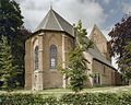
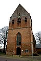
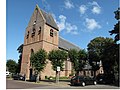
church building in Voorst, Netherlands  | |||||
| Upload media | |||||
| Instance of | |||||
|---|---|---|---|---|---|
| Location | Terwolde, Voorst, Gelderland, Netherlands | ||||
| Street address |
| ||||
| Located on street |
| ||||
| Heritage designation |
| ||||
| Significant event |
| ||||
 | |||||
Nederlands: Dorpskerk Terwolde - anno 15e eeuw
|
This is a category about rijksmonument number 38072
|
| Address |
|
Subcategories
This category has only the following subcategory.
I
Media in category "Kerk Terwolde"
The following 13 files are in this category, out of 13 total.
-
 Dorpskerk Terwolde (31352416901).jpg 4,000 × 3,000; 3.32 MB
-
 Exterieur NOORDGEVEL - Terwolde - 20278152 - RCE.jpg 1,200 × 952; 301 KB
-
 Exterieur OOSTGEVEL - Terwolde - 20278153 - RCE.jpg 1,200 × 956; 336 KB
-
 Exterieur WESTGEVEL - Terwolde - 20278151 - RCE.jpg 956 × 1,200; 268 KB
-
 Kerk vanuit het zuid-westen - Terwolde - 20207837 - RCE.jpg 913 × 1,200; 251 KB
-
 MKZ-monument kerk Terwolde.JPG 2,448 × 3,264; 1.75 MB
-
 Terwolde - Dorpskerk -15.JPG 2,592 × 3,888; 3.04 MB
-
 Terwolde - Dorpskerk.JPG 3,888 × 2,592; 4.21 MB
-
 Terwolde kerk 38072.jpg 4,145 × 2,617; 4.72 MB
-
 Terwolde, kerk foto1 2009-09-12 14.22.JPG 3,456 × 2,592; 1.65 MB
-
 The old Dutch type protestant church of Terwolde in rain at Easter 2012 - panoramio.jpg 4,145 × 3,109; 2.99 MB
-
 Verscholen kerk (30659457723).jpg 3,000 × 4,000; 3.66 MB
-
 Zuid-west zijde - Terwolde - 20207838 - RCE.jpg 819 × 1,200; 227 KB
.jpg)


.jpg)
