Category:Kerklaan 55, Scheemda
Jump to navigation
Jump to search
| Object location | | View all coordinates using: OpenStreetMap |
|---|
 | |||||
| Upload media | |||||
| Instance of | |||||
|---|---|---|---|---|---|
| Location | Scheemda, Groningen, Netherlands | ||||
| Located on street |
| ||||
| Heritage designation |
| ||||
 | |||||
|
This is a category about rijksmonument number 33069
|
| Address |
|
Media in category "Kerklaan 55, Scheemda"
The following 36 files are in this category, out of 36 total.
-

-

-

-
 Interieur, begane grond, overzicht opkamer - Scheemda - 20341537 - RCE.jpg 1,187 × 1,200; 158 KB
-

-

-

-
 Interieur, bovenverdieping, zij- en achtergevel - Scheemda - 20341568 - RCE.jpg 1,187 × 1,200; 258 KB
-
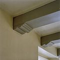
 Interieur, detail plafondconstructie - Scheemda - 20424577 - RCE.jpg 1,200 × 1,200; 275 KB
-
 Interieur, detail schilderij - Scheemda - 20424580 - RCE.jpg 1,200 × 878; 195 KB
-
 Interieur, detail secreet - Scheemda - 20424578 - RCE.jpg 1,200 × 1,200; 288 KB
-
 Interieur, detail, plafondconstructie - Scheemda - 20424582 - RCE.jpg 1,200 × 1,200; 273 KB
-
 Interieur, kelder - Scheemda - 20341570 - RCE.jpg 1,190 × 1,200; 175 KB
-
 Interieur, kelder - Scheemda - 20341571 - RCE.jpg 1,192 × 1,200; 191 KB
-
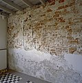 Interieur, ontpleisterde muur - Scheemda - 20341561 - RCE.jpg 1,194 × 1,200; 307 KB
-
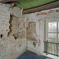
 Interieur, ontpleisterde muur achtergevel - Scheemda - 20341559 - RCE.jpg 1,187 × 1,200; 303 KB
-
 Interieur, opkamer met ontpleisterde gevelvlak - Scheemda - 20341565 - RCE.jpg 1,192 × 1,200; 189 KB
-
 Interieur, overzicht - Scheemda - 20424581 - RCE.jpg 1,200 × 1,200; 269 KB
-

-
 Interieur, overzicht zolderruimte, kapconstructie - Scheemda - 20341554 - RCE.jpg 1,196 × 1,200; 227 KB
-
 Interieur, verdieping, linker voorkamer- console - Scheemda - 20341542 - RCE.jpg 1,196 × 1,200; 174 KB
-

-

-

-
 Interieur, zolder, deel van de kap, kapconstructie - Scheemda - 20341557 - RCE.jpg 1,186 × 1,200; 227 KB
-
 Interieur, zolder, kapconstructie - Scheemda - 20341555 - RCE.jpg 1,187 × 1,200; 235 KB
-
 Interieur, zolder, kapconstructie - Scheemda - 20341556 - RCE.jpg 1,188 × 1,200; 277 KB
-
 Interieur, zolder, kapconstructie - Scheemda - 20341558 - RCE.jpg 1,193 × 1,200; 240 KB
-
 Interieur, zolder, kapcontructie bij de schoorsteen - Scheemda - 20341553 - RCE.jpg 1,200 × 1,178; 247 KB
-
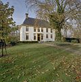
 Ol Pastorie Scheemda.jpg 2,272 × 1,704; 1.7 MB
-
 Overzicht achtergevel- landbouwschuur - Scheemda - 20341536 - RCE.jpg 1,195 × 1,200; 386 KB
-
 Overzicht voorgevel - Scheemda - 20341535 - RCE.jpg 1,187 × 1,200; 430 KB
-
 Overzicht voorgevel en rechter zijgevel - Scheemda - 20341534 - RCE.jpg 1,188 × 1,200; 465 KB
-

-
 Voormalige Pastorie, aanzicht - Eexta - 20067914 - RCE.jpg 1,200 × 961; 315 KB
-
 Voormalige Pastorie, zijaanzicht - Eexta - 20067913 - RCE.jpg 1,200 × 958; 311 KB


