Category:Kerkstraat 30, Tiel
Jump to navigation
Jump to search
| Object location | | View all coordinates using: OpenStreetMap |
|---|
 | |||||
| Upload media | |||||
| Instance of | |||||
|---|---|---|---|---|---|
| Location | Tiel, Gelderland, Netherlands | ||||
| Street address |
| ||||
| Located on street | |||||
| Heritage designation |
| ||||
 | |||||
|
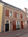
This is a category about rijksmonument number 35574
|
| Address |
|
Media in category "Kerkstraat 30, Tiel"
The following 3 files are in this category, out of 3 total.
-
 Tiel Kerkstraat 30 1.jpg 2,448 × 3,264; 2.74 MB
-
 Tiel Kerkstraat 30 2.jpg 2,448 × 3,264; 2.81 MB
-
 Tiel Rijksmonument 35575 Kerkstraat 30A.JPG 2,736 × 3,648; 3.31 MB

