Category:Kitanglad Mountain Range
Jump to navigation
Jump to search
mountain range that dominates the northern central portion of the province of Bukidnon  | |||||
| Upload media | |||||
| Instance of | |||||
|---|---|---|---|---|---|
| Location |
| ||||
| Heritage designation | |||||
| Inception |
| ||||
| Highest point | |||||
| Area |
| ||||
| Elevation above sea level |
| ||||
 | |||||
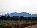
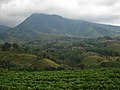
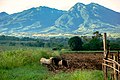
English: Kitanglad Mountain Range is a mountain range that dominates the northern central portion of the Philippine province of Bukidnon on the island of Mindanao.
Nederlands: Het Kitangladgebergte ligt in de provincie Bukidnon in het noorden van het Filipijnse eiland Mindanao.
Subcategories
This category has the following 2 subcategories, out of 2 total.
D
- Mount Dulang-dulang (7 F)
K
Media in category "Kitanglad Mountain Range"
The following 15 files are in this category, out of 15 total.
-
 Kitanglad range central part.JPG 2,304 × 1,728; 2.2 MB
-
 A view of Mt. Kitanglad.jpg 3,456 × 2,304; 1.35 MB
-
 Del Monte Pineapple field at Camp Philips, Bukidnon, Philippines 03.jpg 4,032 × 2,268; 4.34 MB
-
 Eclipse at Kitanglad Range.jpg 4,000 × 6,000; 6.63 MB
-
 Kitanglad mountain range panorama.JPG 1,984 × 356; 437 KB
-
 Kitanglad mountain range songco.JPG 1,280 × 960; 568 KB
-
 Kitanglad Mountain Range.jpg 3,872 × 2,592; 11.05 MB
-
 Mount Kitanglad and the Kitanglad Mountain Range.jpg 4,608 × 3,456; 5.52 MB
-
 Mount Kitanglad Range.jpg 5,282 × 3,508; 15.05 MB
-
 Mount Kitanglad range.jpg 2,048 × 1,353; 609 KB
-
 Mount Kitanglad seen from Camp Philips, Bukidnon 01 (cropped).jpg 4,032 × 576; 805 KB
-
 Mount Kitanglad seen from Camp Philips, Bukidnon 01.jpg 4,032 × 2,268; 2.93 MB
-
 Mount Kitanglad seen from Camp Philips, Bukidnon 02.jpg 4,032 × 2,268; 3.89 MB
-
 Overlooking bukidnon lights and Kitanglad Mountain Range.jpg 5,075 × 3,341; 3.37 MB
-
 Sunset in Bukidnon with both Kitanglad (right) and Kalatungan (left) Ranges visible.jpg 4,032 × 3,024; 3.11 MB


_and_Kalatungan_(left)_Ranges_visible.jpg)
.jpg)