Category:Knorrenburgerstraat 2, Hattem
Jump to navigation
Jump to search
| Object location | | View all coordinates using: OpenStreetMap |
|---|
 | |||||
| Upload media | |||||
| Instance of | |||||
|---|---|---|---|---|---|
| Location | Hattem, Gelderland, Netherlands | ||||
| Street address |
| ||||
| Located on street |
| ||||
| Heritage designation |
| ||||
 | |||||
|
This is a category about rijksmonument number 20961
|
| Address |
|
Media in category "Knorrenburgerstraat 2, Hattem"
The following 7 files are in this category, out of 7 total.
-
 Gevel tussen 1e en 2e steeg - Hattem - 20103349 - RCE.jpg 802 × 1,200; 208 KB
-
 Hattem Knorrenburgerstraat Pakhuizen.JPG 1,704 × 2,272; 505 KB
-
 Hattem, Netherlands - panoramio (44).jpg 1,155 × 2,048; 566 KB
-
 Hattem, Netherlands - panoramio (51).jpg 1,155 × 2,048; 540 KB
-
 Schuur - Hattem - 20103352 - RCE.jpg 1,200 × 1,195; 317 KB
-
 Voorgevel - Hattem - 20103351 - RCE.jpg 1,200 × 1,190; 299 KB
-
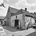 Voorgevels - Hattem - 20103350 - RCE.jpg 1,200 × 1,200; 302 KB

.jpg)
.jpg)


