Category:Koornmarktspoort
Jump to navigation
Jump to search
| Object location | | View all coordinates using: OpenStreetMap |
|---|
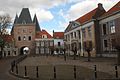
city gate in Kampen, Netherlands  | |||||
| Upload media | |||||
| Instance of | |||||
|---|---|---|---|---|---|
| Location | Kampen, Overijssel, Netherlands | ||||
| Owned by | |||||
| Heritage designation |
| ||||
 | |||||
|
This is a category about rijksmonument number 23445
|
| Address |
|
Subcategories
This category has the following 2 subcategories, out of 2 total.
B
- Binnenzijde Koornmarktspoort (18 F)
- Buitenzijde Koornmarktspoort (37 F)
Media in category "Koornmarktspoort"
The following 84 files are in this category, out of 84 total.
-
 Aanzicht - Kampen - 20123434 - RCE.jpg 1,186 × 1,200; 325 KB
-
 Exterieur BEELD AFKOMSTIG VAN HET STADHUIS - Kampen - 20262892 - RCE.jpg 779 × 1,200; 221 KB
-

-

-
-

-

-

-

-

-

-

-

-

-

-

-

-
-

-

-
-

-

-

-

-

-

-

-

-
-

-

-

-

-

-

-

-

-

-

-

-

-

-

-

-

-

-

-

-

-

-

-

-

-

-
 INTERIEUR, BEELD AFKOMSTIG VAN HET STADHUIS - Kampen - 20262887 - RCE.jpg 551 × 1,200; 167 KB
-
 INTERIEUR, BEELD AFKOMSTIG VAN HET STADHUIS - Kampen - 20262890 - RCE.jpg 819 × 1,200; 258 KB
-
 INTERIEUR, BEELD AFKOMSTIG VAN HET STADHUIS - Kampen - 20262891 - RCE.jpg 432 × 1,200; 143 KB
-
 INTERIEUR, BEELD AFKOMSTIG VAN HET STADHUIS - Kampen - 20262893 - RCE.jpg 774 × 1,200; 259 KB
-
 INTERIEUR, BEELD AFKOMSTIG VAN HET STADHUIS - Kampen - 20262895 - RCE.jpg 463 × 1,200; 144 KB
-
 INTERIEUR, BEELD AFKOMSTIG VAN HET STADHUIS - Kampen - 20262896 - RCE.jpg 291 × 1,200; 94 KB
-
 INTERIEUR, BEELD AFKOMSTIG VAN HET STADHUIS - Kampen - 20262897 - RCE.jpg 794 × 1,200; 217 KB
-
 INTERIEUR, BEELD AFKOMSTIG VAN HET STADHUIS - Kampen - 20262898 - RCE.jpg 779 × 1,200; 196 KB
-
 INTERIEUR, BEELD AFKOMSTIG VAN HET STADHUIS - Kampen - 20262900 - RCE.jpg 775 × 1,200; 204 KB
-
 INTERIEUR, BEELD AFKOMSTIG VAN HET STADHUIS - Kampen - 20262902 - RCE.jpg 503 × 1,200; 161 KB
-
 INTERIEUR, BEELD AFKOMSTIG VAN HET STADHUIS - Kampen - 20262903 - RCE.jpg 490 × 1,200; 152 KB
-
 INTERIEUR, BEELD AFKOMSTIG VAN HET STADHUIS - Kampen - 20262904 - RCE.jpg 794 × 1,200; 244 KB
-
 INTERIEUR, BEELDEN AFKOMSTIG VAN HET STADHUIS - Kampen - 20262888 - RCE.jpg 618 × 1,200; 197 KB
-
 INTERIEUR, BEELDEN AFKOMSTIG VAN HET STADHUIS - Kampen - 20262889 - RCE.jpg 482 × 1,200; 150 KB
-
 INTERIEUR, BEELDEN AFKOMSTIG VAN HET STADHUIS - Kampen - 20262899 - RCE.jpg 802 × 1,200; 239 KB
-

-

-
 Kampen - IJsselkade - View ESE on 14th Century Koornmarktspoort I.jpg 6,048 × 4,032; 28.24 MB
-
 Kampen - IJsselkade - View ESE on 14th Century Koornmarktspoort II.jpg 5,872 × 3,914; 18.97 MB
-
 Kampen - Koornmarkt - View ENE on 14th Century Koornmarktspoort.jpg 3,974 × 5,962; 19.67 MB
-
 Kampen - Koornmarkt - View NE towards 14th Century Koornmarktspoort.jpg 5,946 × 3,964; 19.3 MB
-
 Kampen, Koornmarkspoort met Theologische Universiteit (4 april 2015) 015.JPG 2,391 × 1,594; 1.75 MB
-
 Kampen, Koornmarktspoort (6 april 2015) detail 01.JPG 1,728 × 2,592; 2.33 MB
-
 Kampen, Koornmarktspoort. 10-01-2022. (actm.) 01.jpg 2,965 × 4,448; 7.76 MB
-
 Kampen, Koornmarktspoort. 10-01-2022. (actm.) 02.jpg 2,973 × 4,459; 10.43 MB
-

-

-
 Stadsmuur, naast Koornmarktspoort - Kampen - 20121636 - RCE.jpg 1,200 × 807; 301 KB
-
 Zicht op Kampen 5 augustus 2014 met zwanen vk.JPG 2,441 × 1,627; 1.99 MB


_-_Kampen_-_20121698_-_RCE.jpg)
_-_Kampen_-_20121699_-_RCE.jpg)
_-_Kampen_-_20121700_-_RCE.jpg)
_-_Kampen_-_20121701_-_RCE.jpg)
_-_Kampen_-_20121702_-_RCE.jpg)
_-_Kampen_-_20121703_-_RCE.jpg)
_-_Kampen_-_20121704_-_RCE.jpg)
_-_Kampen_-_20121705_-_RCE.jpg)
_-_Kampen_-_20121706_-_RCE.jpg)
_-_Kampen_-_20121707_-_RCE.jpg)
_-_Kampen_-_20121708_-_RCE.jpg)
_-_Kampen_-_20121709_-_RCE.jpg)
_-_Kampen_-_20121710_-_RCE.jpg)
_-_Kampen_-_20121711_-_RCE.jpg)
_-_Kampen_-_20121712_-_RCE.jpg)
_-_Kampen_-_20121713_-_RCE.jpg)
_-_Kampen_-_20121714_-_RCE.jpg)
_-_Kampen_-_20121715_-_RCE.jpg)
_-_Kampen_-_20121716_-_RCE.jpg)
_-_Kampen_-_20121717_-_RCE.jpg)
_-_Kampen_-_20121718_-_RCE.jpg)
_-_Kampen_-_20121719_-_RCE.jpg)
_-_Kampen_-_20121720_-_RCE.jpg)
_-_Kampen_-_20121721_-_RCE.jpg)
_-_Kampen_-_20121722_-_RCE.jpg)
_-_Kampen_-_20121723_-_RCE.jpg)
_-_Kampen_-_20121724_-_RCE.jpg)
_-_Kampen_-_20121725_-_RCE.jpg)
_-_Kampen_-_20121726_-_RCE.jpg)
_-_Kampen_-_20121727_-_RCE.jpg)
_-_Kampen_-_20121728_-_RCE.jpg)
_-_Kampen_-_20121729_-_RCE.jpg)
_-_Kampen_-_20121730_-_RCE.jpg)
_-_Kampen_-_20121731_-_RCE.jpg)
_-_Kampen_-_20121732_-_RCE.jpg)
_-_Kampen_-_20121733_-_RCE.jpg)
_-_Kampen_-_20121734_-_RCE.jpg)
_-_Kampen_-_20121735_-_RCE.jpg)
_-_Kampen_-_20121736_-_RCE.jpg)
_-_Kampen_-_20121737_-_RCE.jpg)
_-_Kampen_-_20121738_-_RCE.jpg)
_-_Kampen_-_20121739_-_RCE.jpg)
_-_Kampen_-_20121740_-_RCE.jpg)
_-_Kampen_-_20121741_-_RCE.jpg)
_-_Kampen_-_20121742_-_RCE.jpg)
_-_Kampen_-_20121743_-_RCE.jpg)
_-_Kampen_-_20121744_-_RCE.jpg)
_-_Kampen_-_20121745_-_RCE.jpg)
_-_Kampen_-_20121746_-_RCE.jpg)
_-_Kampen_-_20121747_-_RCE.jpg)
_-_Kampen_-_20121748_-_RCE.jpg)
_-_Kampen_-_20121749_-_RCE.jpg)
_-_Kampen_-_20121750_-_RCE.jpg)


_015.JPG)
_detail_01.JPG)
_01.jpg)
_02.jpg)


