Category:Kromhoutkazerne (Tilburg)
Jump to navigation
Jump to search
| Object location | | View all coordinates using: OpenStreetMap |
|---|
 | |||||
| Upload media | |||||
| Instance of | |||||
|---|---|---|---|---|---|
| Location | Tilburg, North Brabant, Netherlands | ||||
| Street address |
| ||||
| Located on street |
| ||||
| Heritage designation |
| ||||
 | |||||
|
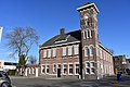
This is a category about rijksmonument number 521197
|
| Address |
|
Media in category "Kromhoutkazerne (Tilburg)"
The following 8 files are in this category, out of 8 total.
-
 Henriëtte Ronnerstraat 1, Tilburg (2).jpg 6,000 × 4,000; 6.65 MB
-
 Henriëtte Ronnerstraat 1, Tilburg (3).jpg 4,000 × 6,000; 7.49 MB
-
 Henriëtte Ronnerstraat 1, Tilburg.jpg 6,000 × 4,000; 6.95 MB
-
 Kromhoutkazerne.jpg 3,648 × 2,736; 2.18 MB
-

-
 Overzicht voorgevel met klokkentoren, kazerne - Tilburg - 20344222 - RCE.jpg 1,188 × 1,200; 259 KB
-

-
 Tilburg - Kromhoutkazerne.jpg 3,000 × 2,573; 5.6 MB
.jpg)
.jpg)


