Category:Kronberg (mountain)
Jump to navigation
Jump to search
Deutsch: Der Kronberg ist ein 1'662,8 m ü. M. hoher Berg im Kanton Appenzell Innerrhoden (Ostschweiz).
| Object location | | View all coordinates using: OpenStreetMap |
|---|
mountain of the Appenzell Alps  | |||||
| Upload media | |||||
| Instance of | |||||
|---|---|---|---|---|---|
| Part of | |||||
| Location | Appenzell Innerrhoden, Switzerland | ||||
| Mountain range | |||||
| Topographic prominence |
| ||||
| Topographic isolation |
| ||||
| Elevation above sea level |
| ||||
| Parent peak | |||||
 | |||||
Subcategories
This category has the following 2 subcategories, out of 2 total.
K
- Kapelle St.Jakob (Kronberg) (5 F)
L
Media in category "Kronberg (mountain)"
The following 40 files are in this category, out of 40 total.
-
 2011-03-07 10-01-12 Switzerland Kanton Appenzell Ausserrhoden Niederteufen.jpg 4,288 × 1,816; 3.74 MB
-
 Aerial View of Kronberg and Säntis 14.02.2008 14-43-45.JPG 2,048 × 1,536; 2.3 MB
-
 Appenzell - Le Pays d'Appenzell.JPG 3,264 × 2,448; 3.46 MB
-
 CH-NB - Kronberg, Jakobsbrunnen, Gesamtansicht - Collection Gugelmann - GS-GUGE-GESSNER-S-1-42.tif 6,081 × 4,509, 2 pages; 67.83 MB
-
 ETH-BIB-Gäbris mit Säntis, Kronenberg u. Hundwilerhöhe-Fel 012137-RE (cropped).jpg 2,019 × 1,308; 518 KB
-
 ETH-BIB-Gäbris mit Säntis, Kronenberg u. Hundwilerhöhe-Fel 012137-RE.jpg 2,272 × 1,704; 898 KB
-
 ETH-BIB-Hundwilerhöhi, Säntis v. N. W. aus 1200 m-Inlandflüge-LBS MH01-005723.tif 6,910 × 5,056; 100.12 MB
-

-
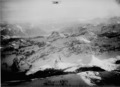 ETH-BIB-Kronberg, Säntis, Rheintal v. N. W. aus 3200 m-Inlandflüge-LBS MH01-002515.tif 5,536 × 4,032; 63.94 MB
-

-
 Girenspitz und Blauschnee.JPG 2,272 × 1,704; 749 KB
-
 Gonten20090124Y888 246.jpg 1,280 × 851; 237 KB
-
 Kronberg Alp.jpeg 3,747 × 2,595; 1.84 MB
-
 Kronberg aus NO.JPG 5,184 × 3,456; 6.27 MB
-
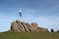
 Kronberg Gipfelfahne.JPG 3,456 × 5,184; 3.41 MB
-
 Kronberg Gipfelweg.JPG 4,032 × 3,024; 2.56 MB
-
 Kronberg im Winter (Blick vom Säntis, 2013).jpg 4,200 × 2,800; 6.82 MB
-
 Kronberg nach SW.JPG 5,184 × 3,456; 3.34 MB
-
 Kronberg Nagelfluh.JPG 5,184 × 3,456; 7.09 MB
-
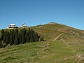
 Kronberg Restaurant.JPG 5,184 × 3,456; 3.88 MB
-
 Kronberg Scheidegg.JPG 5,184 × 3,456; 6.83 MB
-
 Kronberg von NO b.JPG 5,184 × 3,456; 6.78 MB
-
 KronbergGipfel02.jpg 4,000 × 3,000; 3.66 MB
-
 Luftbild Ebenalp.jpg 1,296 × 972; 347 KB
-
 Picswiss AI-05-01.jpg 500 × 333; 54 KB
-
 Picswiss AI-05-03.jpg 500 × 333; 32 KB
-
 Picswiss AI-05-04.jpg 501 × 333; 42 KB
-
 Picswiss AI-05-07.jpg 500 × 333; 40 KB
-
 Picswiss AI-05-08.jpg 500 × 333; 45 KB
-
 Picswiss AI-05-09.jpg 300 × 450; 63 KB
-
 Picswiss AI-05-10.jpg 300 × 450; 57 KB
-
 Picswiss AI-05-11.jpg 500 × 333; 51 KB
-
 Picswiss AI-05-12.jpg 500 × 333; 52 KB
-
 Picswiss AI-05-13.jpg 500 × 333; 47 KB
-
 Picswiss AI-05-14.jpg 500 × 333; 37 KB
-
 Picswiss AI-05-15.jpg 500 × 333; 41 KB
-
 Picswiss AI-05-16.jpg 500 × 333; 42 KB
-
 Rheintal at Night - panoramio.jpg 1,280 × 556; 602 KB
-
 Wanderwegweiser Kronberg 1650 1.jpg 4,032 × 3,024; 2.08 MB
-
 Wanderwegweiser Kronberg 1650 2.jpg 4,032 × 3,024; 888 KB


.jpg)


.jpg)


