Category:Ksour Range
Jump to navigation
Jump to search
mountains in Algeria  Το Αΐν Σεφρά και η οροσειρά Κσουρ στο φόντο | |||||
| Upload media | |||||
| Instance of | |||||
|---|---|---|---|---|---|
| Location |
| ||||
| Mountain range |
| ||||
| Highest point |
| ||||
| Elevation above sea level |
| ||||
 | |||||
Subcategories
This category has only the following subcategory.
N
- Neolithic art in Ain Sefra (18 F)
Media in category "Ksour Range"
The following 9 files are in this category, out of 9 total.
-
 Ain Ouerka 3 عين ورقة.jpg 3,000 × 1,688; 1.58 MB
-
 Ain Ouerka 4 عين ورقة.jpg 3,500 × 1,632; 1.53 MB
-
 Ain Ouerka عين ورقة 1.jpg 2,500 × 1,666; 569 KB
-
 Ain Ouerka عين ورقة 2.jpg 3,000 × 1,687; 981 KB
-
 Algerian Jebel Amour rug, 19th century or earlier (detail).png 654 × 1,332; 2.4 MB
-
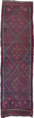 Algerian Jebel Amour rug, 19th century or earlier.png 386 × 1,336; 1.51 MB
-
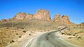
 Figig.jpg 592 × 393; 41 KB
-
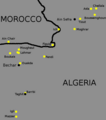 Ksours of Algeria.png 655 × 743; 30 KB
-
 Vue d Ain Sefra, Algérie.jpg 1,024 × 768; 372 KB


.png)

