Category:Kupfer (Fluss)
Jump to navigation
Jump to search
Deutsch: Die Kupfer ist ein etwa 26 Kilometer langer Fluss, der in Kupferzell durch die Hohenloher Ebene fließt und bei Forchtenberg im Hohenlohekreis im nördlichen Baden-Württemberg von links und Süden in den Kocher mündet.
English: The Kupfer is a river with a length of about 26 km. It flows through the Hohenloher Ebene and joins the Kocher at Forchtenberg in district Hohenlohekreis in northern Baden-Württemberg.
river in Germany   | |||||
| Upload media | |||||
| Instance of | |||||
|---|---|---|---|---|---|
| Location | Baden-Württemberg, Germany | ||||
| Length |
| ||||
| Mouth of the watercourse | |||||
| Drainage basin | |||||
 | |||||
Subcategories
This category has the following 2 subcategories, out of 2 total.
L
Media in category "Kupfer (Fluss)"
The following 11 files are in this category, out of 11 total.
-
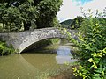 Alte Steinbrücke über die Kupfer - panoramio.jpg 2,008 × 1,506; 793 KB
-
 Forchtenberg Kocher Kupfer Muehlwehr 235 P1050212 20200605.jpg 3,785 × 2,523; 3.41 MB
-
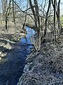
 Kupfer beim Schwarzen Steg.jpg 2,816 × 2,112; 2.84 MB
-
 Kupfer, Stegmühle 202102 01.jpg 3,024 × 4,032; 5.02 MB
-
 Kupfer, Stegmühle 202102 02.jpg 3,024 × 4,032; 5.27 MB
-
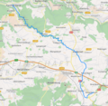 Kupfer.png 635 × 620; 533 KB
-
 Kupferbrückle unterhalb Weckhof 2009-05-23 1.jpg 3,072 × 2,304; 4.62 MB
-
 Kupferbrückle unterhalb Weckhof 2009-05-23 2.jpg 2,304 × 3,072; 4.55 MB
-
 Kupferbrückle unterhalb Weckhof 2009-05-23 3.jpg 2,304 × 3,072; 4.18 MB
-
 Kupfertal Schwarzer Steg 2012 01.jpg 2,816 × 2,112; 2.87 MB
-
 Kupfertal Schwarzer Steg 2012 02.jpg 2,826 × 1,748; 3.49 MB


