Category:Land common to Hamsterley, Lynesack and Softley, and South Bedburn
Jump to navigation
Jump to search
English: Land common to Hamsterley, Lynesack and Softley and South Bedburn is a civil parish in the in the county of County Durham, England.
civil parish in County Durham, England | |||||
| Upload media | |||||
| Instance of | |||||
|---|---|---|---|---|---|
| Location | County Durham, North East England, England | ||||
| Maintained by | |||||
 | |||||
Media in category "Land common to Hamsterley, Lynesack and Softley, and South Bedburn"
The following 37 files are in this category, out of 37 total.
-
 Autumnal larches beside forest road - geograph.org.uk - 6316954.jpg 2,000 × 1,481; 3.64 MB
-
 Bridleway crossing snowed heather moor - geograph.org.uk - 2207612.jpg 2,000 × 1,178; 2.23 MB
-
 Cairn on moorland south of South Grain Beck - geograph.org.uk - 5249154.jpg 1,500 × 889; 1.13 MB
-
 Curious right of way near Black Hill - geograph.org.uk - 2207284.jpg 2,000 × 1,500; 2.34 MB
-
 Doctor's Gate - geograph.org.uk - 269506.jpg 640 × 480; 59 KB
-
 Doctor's Gate - geograph.org.uk - 957942.jpg 640 × 480; 62 KB
-
 Enclosures near the Meeting of the Grains - geograph.org.uk - 4768758.jpg 1,500 × 1,125; 1.92 MB
-
 Entrance drive to Shipley Moss Farm off Howlea Lane - geograph.org.uk - 3041502.jpg 3,648 × 2,736; 2.45 MB
-
 Eroded route heading towards Doctor's Gate - geograph.org.uk - 5684100.jpg 1,500 × 886; 1,013 KB
-

-
 Felled - geograph.org.uk - 1892117.jpg 2,048 × 1,536; 990 KB
-
 Ford over the South Grain Beck - geograph.org.uk - 510904.jpg 640 × 480; 105 KB
-
 Hamsterley Common - geograph.org.uk - 4846927.jpg 640 × 480; 83 KB
-
 Hill road in valley of Ayhope Beck - geograph.org.uk - 6316191.jpg 1,600 × 985; 547 KB
-
 Hollow on moorland near to Cliff Sike Beck - geograph.org.uk - 5684101.jpg 1,500 × 1,001; 1.25 MB
-
 Looking towards Doctor's Gate - geograph.org.uk - 2881818.jpg 4,608 × 3,456; 5.13 MB
-
 New track near Doctor's Gate - geograph.org.uk - 268861.jpg 640 × 480; 81 KB
-
 Old road at Doctor's Gate - geograph.org.uk - 269507.jpg 640 × 480; 82 KB
-
 Old track near Doctor's Gate. - geograph.org.uk - 268859.jpg 640 × 480; 79 KB
-
 Pikestone Fellside - geograph.org.uk - 958792.jpg 640 × 480; 84 KB
-
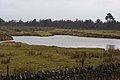
 Pool at Ayhope Shield - geograph.org.uk - 3689706.jpg 1,500 × 1,000; 1.51 MB
-
 Quarry - geograph.org.uk - 3265500.jpg 1,824 × 1,216; 934 KB
-
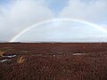 Rainbow on Black Hill - geograph.org.uk - 4846922.jpg 640 × 480; 43 KB
-

-
 Shallow Quarry Near Doctor's Gate - geograph.org.uk - 2022110.jpg 1,500 × 1,083; 1.73 MB
-
 Slope with birch trees above minor stream - geograph.org.uk - 5013480.jpg 1,200 × 1,600; 1.07 MB
-
 Snowed heather moor with birch tree - geograph.org.uk - 2207236.jpg 2,000 × 1,500; 2.8 MB
-

-
 South Grain Beck - geograph.org.uk - 4846907.jpg 640 × 480; 84 KB
-
 South Grain Beck - geograph.org.uk - 510876.jpg 480 × 640; 87 KB
-

-
 Track for Monkfield Farm from Knitsley Fell - geograph.org.uk - 3340049.jpg 3,648 × 2,736; 2.75 MB
-
 Track to Shipley Moss - geograph.org.uk - 5907614.jpg 640 × 480; 47 KB
-
 Tree with crag - geograph.org.uk - 4184689.jpg 1,500 × 910; 1.49 MB
-
 Trees beside moorland groove - geograph.org.uk - 5248202.jpg 1,500 × 909; 1.17 MB
-
 View East from Cabin Hill - geograph.org.uk - 2881794.jpg 4,608 × 3,456; 5.13 MB
-
 West Moor Plantation - geograph.org.uk - 2468338.jpg 1,500 × 843; 1.15 MB


