Category:Langbroekerdijk A 30, Langbroek
Jump to navigation
Jump to search
| Object location | | View all coordinates using: OpenStreetMap |
|---|
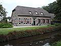
farmhouse in Wijk bij Duurstede, Netherlands  | |||||
| Upload media | |||||
| Instance of | |||||
|---|---|---|---|---|---|
| Location | Langbroek, Utrecht, Netherlands | ||||
| Street address |
| ||||
| Located on street |
| ||||
| Heritage designation |
| ||||
 | |||||
|
This is a category about rijksmonument number 23898
|
| Address |
|
Media in category "Langbroekerdijk A 30, Langbroek"
The following 4 files are in this category, out of 4 total.
-
 4 - Langbroek - 20459400 - RCE.jpg 1,200 × 900; 142 KB
-
 A voor- en zijgevel - Neerlangbroek - 20163057 - RCE.jpg 1,200 × 802; 178 KB
-
 RM23898 Langbroekerdijk A30.JPG 4,320 × 3,240; 1.85 MB
-
 Traqditional farm along the Langbroeker Wetering - panoramio.jpg 4,928 × 3,264; 4.86 MB


