Category:Leek Wootton and Guy's Cliffe
Jump to navigation
Jump to search
English: Leek Wootton and Guy's Cliffe is a civil parish in the Warwick district, in the county of Warwickshire, England.

civil parish in Warwickshire, United Kingdom | |||||
| Upload media | |||||
| Instance of | |||||
|---|---|---|---|---|---|
| Location | Warwick, Warwickshire, West Midlands, England | ||||
 | |||||
Subcategories
This category has the following 3 subcategories, out of 3 total.
Media in category "Leek Wootton and Guy's Cliffe"
The following 200 files are in this category, out of 261 total.
(previous page) (next page)-
 10th Tee - geograph.org.uk - 2868055.jpg 640 × 480; 74 KB
-

-
 A bare field - geograph.org.uk - 6162610.jpg 2,000 × 1,330; 2.02 MB
-
 A field north of Wootton Spinnies - geograph.org.uk - 1572430.jpg 640 × 426; 123 KB
-

-
 A grassed area by the footpath - geograph.org.uk - 2969146.jpg 2,000 × 1,433; 457 KB
-
 A paddock near Goodrest Farm - geograph.org.uk - 1584756.jpg 640 × 426; 343 KB
-
 A pond north-west of Larch Covert - geograph.org.uk - 1584867.jpg 640 × 427; 370 KB
-
 A southeast prospect from Prospect Lane - geograph.org.uk - 6054671.jpg 1,024 × 768; 1.22 MB
-
 A429 northbound joining A46 - geograph.org.uk - 3581344.jpg 1,024 × 769; 89 KB
-
 A452 Approaching Island For A46 - geograph.org.uk - 3693644.jpg 640 × 480; 68 KB
-
 A46 - A452 junction for Warwick - geograph.org.uk - 2902699.jpg 640 × 480; 67 KB
-

-

-
 A46 - geograph.org.uk - 3356196.jpg 640 × 368; 37 KB
-

-
 A46 - Thickthorn junction bridges - geograph.org.uk - 2902658.jpg 640 × 480; 56 KB
-
 A46 - Woodloes Lane bridge - geograph.org.uk - 2902711.jpg 640 × 480; 60 KB
-

-
 A46 at the A452 junction - geograph.org.uk - 2902703.jpg 640 × 480; 51 KB
-
 A46 crossing Hill Wootton Road - geograph.org.uk - 2902694.jpg 640 × 480; 65 KB
-
 A46 junction with A429 - geograph.org.uk - 5165989.jpg 3,008 × 2,000; 694 KB
-
 A46 Kenilworth bypass - geograph.org.uk - 4445273.jpg 1,024 × 680; 149 KB
-
 A46 south of the A452 junction - geograph.org.uk - 2902707.jpg 640 × 480; 47 KB
-
 A46 south of Thickthorn junction - geograph.org.uk - 2902662.jpg 640 × 480; 62 KB
-
 A46 Southbound Exit for Warwick A429 - geograph.org.uk - 3696045.jpg 640 × 441; 50 KB
-

-
 A46 Warwick Bypass from Woodloes Lane - geograph.org.uk - 6268015.jpg 5,456 × 3,632; 5.1 MB
-
 Activity Centre - geograph.org.uk - 2867980.jpg 640 × 472; 85 KB
-
 Adventure sports open area, Wedgnock - geograph.org.uk - 1588719.jpg 640 × 427; 377 KB
-
-

-

-
 Apparent earth dam between bluffs - geograph.org.uk - 1589150.jpg 640 × 426; 275 KB
-
 Approaching Deer Park Wood - geograph.org.uk - 1613014.jpg 640 × 480; 100 KB
-

-

-
 Area for clay pigeon shooting, Wedgnock - geograph.org.uk - 1588905.jpg 640 × 427; 380 KB
-
 B4115 towards Warwick - geograph.org.uk - 4445281.jpg 1,024 × 682; 242 KB
-
 Back to nature - geograph.org.uk - 2123527.jpg 6,048 × 4,032; 1.49 MB
-

-

-
 Bean Field near the Cape - geograph.org.uk - 2868046.jpg 640 × 482; 120 KB
-

-
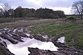
 Boundary ditch, The Warwickshire - geograph.org.uk - 1584701.jpg 640 × 427; 502 KB
-
 Bridge across A46, Wootton Spinnies - geograph.org.uk - 1572444.jpg 640 × 427; 174 KB
-
 Bridleway at side of Deer Park Wood - geograph.org.uk - 3147168.jpg 640 × 480; 132 KB
-
 Bridleway to Rouncil Lane - geograph.org.uk - 3368959.jpg 2,000 × 1,500; 507 KB
-
 Bridleway to Rouncil Lane - geograph.org.uk - 3370273.jpg 2,000 × 1,500; 632 KB
-
 Bridleway towards Prospect Farm - geograph.org.uk - 3368943.jpg 2,000 × 1,500; 552 KB
-
 Buildings at Prospect Farm - geograph.org.uk - 2867924.jpg 640 × 480; 61 KB
-

-
 Car park of the Anchor Inn, Leek Wootton - geograph.org.uk - 6357560.jpg 1,024 × 614; 170 KB
-
 Centenary Way footpath - geograph.org.uk - 2969024.jpg 2,000 × 1,501; 482 KB
-
 Centenary Way footpath - geograph.org.uk - 2969278.jpg 2,000 × 1,408; 440 KB
-
 Centenary Way footpath - geograph.org.uk - 2969938.jpg 2,000 × 1,499; 484 KB
-
 Centenary Way footpath - geograph.org.uk - 2969960.jpg 1,500 × 1,994; 553 KB
-
 Chesford Bridge - geograph.org.uk - 5301890.jpg 1,280 × 960; 529 KB
-
 Chesford Grange Hotel - geograph.org.uk - 2553064.jpg 800 × 641; 95 KB
-
 Chesford Grange Hotel - geograph.org.uk - 3535944.jpg 1,024 × 768; 186 KB
-
 Converted barn, Middle Woodloes - geograph.org.uk - 1583211.jpg 640 × 427; 441 KB
-
 Copse Near Wedgnock Park Farm - geograph.org.uk - 2197404.jpg 640 × 480; 114 KB
-

-
 Corner of wood east of Middle Woodloes - geograph.org.uk - 1583056.jpg 640 × 426; 358 KB
-

-
 Countryside near Deer Park Farm - geograph.org.uk - 2867860.jpg 640 × 480; 120 KB
-
 Countryside near Kenilworth - geograph.org.uk - 2170986.jpg 640 × 387; 55 KB
-
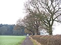
 Countryside near Leek Wootton - geograph.org.uk - 2170561.jpg 640 × 480; 90 KB
-
 Countryside near Leek Wootton - geograph.org.uk - 2379310.jpg 640 × 480; 99 KB
-
 Croft Road, Leek Wootton - geograph.org.uk - 1579251.jpg 640 × 427; 81 KB
-
 Crop stalks east of Woodloes farm - geograph.org.uk - 1583352.jpg 640 × 427; 536 KB
-
 Crops and hedgerows northwest of Warwick - geograph.org.uk - 6170963.jpg 1,024 × 614; 296 KB
-
 Crossing the railway, Wootton Spinnies - geograph.org.uk - 1572432.jpg 640 × 480; 160 KB
-
 Crossroads under a railway bridge - geograph.org.uk - 2825399.jpg 640 × 480; 102 KB
-
 Daffodils along the A429 - geograph.org.uk - 4445728.jpg 906 × 1,024; 369 KB
-
 Dead hedgerow elms, Wedgnock Lane - geograph.org.uk - 1448424.jpg 640 × 427; 111 KB
-
 Deer Park Wood beyond new gates - geograph.org.uk - 1584877.jpg 640 × 426; 321 KB
-

-
 Dried up pond by Centenary Way - geograph.org.uk - 2969986.jpg 2,000 × 1,333; 434 KB
-
 Driveway through Wedgnock Deer Park - geograph.org.uk - 3147136.jpg 640 × 480; 118 KB
-
 Driving range building - geograph.org.uk - 2969050.jpg 2,000 × 1,498; 295 KB
-
 Easy curve on the A46 - geograph.org.uk - 2902695.jpg 640 × 480; 66 KB
-
 Emerging grass near Chesford Bridge - geograph.org.uk - 1597815.jpg 640 × 426; 85 KB
-

-
 Entrance to Jolly's Circus - geograph.org.uk - 4445524.jpg 1,024 × 733; 245 KB
-
 Entrance to Woodcote, Woodcote Lane - geograph.org.uk - 1578944.jpg 640 × 427; 136 KB
-
 Explanation board, Banner Hill camp - geograph.org.uk - 3115000.jpg 640 × 484; 68 KB
-
 Farm Track from Prospect Farm - geograph.org.uk - 2867934.jpg 640 × 459; 78 KB
-
 Farm track leading to Blacklow Hill - geograph.org.uk - 6265191.jpg 5,456 × 3,632; 5.11 MB
-
 Farmland along the B4115 - geograph.org.uk - 4445293.jpg 1,024 × 724; 250 KB
-
 Farmland near Wedgnock Lane - geograph.org.uk - 1584891.jpg 640 × 384; 277 KB
-
 Farmland south of Kenilworth - geograph.org.uk - 3356195.jpg 640 × 352; 38 KB
-
 Farmland, Field Barn Farm - geograph.org.uk - 3356205.jpg 640 × 430; 36 KB
-
 Fence to a paddock north of Leek Wootton - geograph.org.uk - 1572476.jpg 640 × 427; 115 KB
-
 Field north of Middle Woodloes - geograph.org.uk - 1583215.jpg 640 × 426; 309 KB
-
 Field of stubble by Wootton Spinnies - geograph.org.uk - 1594299.jpg 640 × 427; 92 KB
-
 Fields at Leek Wootton - geograph.org.uk - 2170305.jpg 640 × 480; 67 KB
-
 Fields at Wedgnock - geograph.org.uk - 2868040.jpg 640 × 480; 91 KB
-
 Fields near Goodrest Farm - geograph.org.uk - 1579056.jpg 640 × 427; 96 KB
-
 Fields near Middle Woodloes - geograph.org.uk - 1583207.jpg 640 × 427; 395 KB
-
 Fields to the north of the A46 Warwick bypass - geograph.org.uk - 1703575.jpg 2,000 × 1,489; 324 KB
-
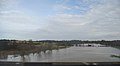 Flooding, River Avon - geograph.org.uk - 3356214.jpg 640 × 351; 26 KB
-

-
 Footbridge Crossing The A46 - geograph.org.uk - 3696039.jpg 640 × 412; 49 KB
-
 Footbridge near Wedgnock Lane over A46 - geograph.org.uk - 3581303.jpg 1,024 × 769; 105 KB
-
 Footbridge over A46, near Warwick - geograph.org.uk - 5166003.jpg 3,008 × 2,000; 729 KB
-
 Footpath through Terrace Hill Wood - geograph.org.uk - 2969185.jpg 1,500 × 2,006; 458 KB
-
 Footpath through Terrace Hill Wood - geograph.org.uk - 2969261.jpg 1,500 × 2,004; 297 KB
-
 Footpath through the golf course - geograph.org.uk - 2969063.jpg 2,000 × 1,500; 428 KB
-
 Footpath through the golf course - geograph.org.uk - 2970010.jpg 2,000 × 1,498; 291 KB
-
 Footpath to Leek Wootton - geograph.org.uk - 2969996.jpg 2,000 × 1,498; 334 KB
-
 Gaveston Wood - geograph.org.uk - 2379399.jpg 640 × 479; 78 KB
-
 Gaveston's Cross - geograph.org.uk - 5405894.jpg 600 × 800; 158 KB
-
 Gaveston's Wood - geograph.org.uk - 3061585.jpg 800 × 600; 101 KB
-
 Go Around - geograph.org.uk - 2123508.jpg 6,048 × 4,032; 1.02 MB
-
 Golf carts - Warwickshire Golf and Country Club - geograph.org.uk - 4236059.jpg 1,280 × 851; 258 KB
-
 Golf driving range, The Warwickshire - geograph.org.uk - 1584667.jpg 640 × 427; 306 KB
-
 Goodrest Farm - geograph.org.uk - 1612974.jpg 640 × 480; 63 KB
-
 Goodrest Farm - geograph.org.uk - 1612980.jpg 640 × 480; 95 KB
-
 Heading north along the B4115 - geograph.org.uk - 4445488.jpg 1,024 × 617; 96 KB
-
 Heading out of Leek Wootton - geograph.org.uk - 6162519.jpg 2,000 × 1,330; 2.01 MB
-
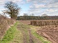
 Headland south-east of Goodrest Farm - geograph.org.uk - 1584713.jpg 640 × 427; 450 KB
-
 Hedgerow in the Avon Valley - geograph.org.uk - 3356210.jpg 640 × 430; 38 KB
-
 Hill Wootton Road crosses the River Avon - geograph.org.uk - 1594578.jpg 640 × 480; 172 KB
-
 Holly and sycamore, Wootton Spinnies - geograph.org.uk - 1572431.jpg 640 × 427; 153 KB
-
 Houses in The Elms - geograph.org.uk - 6062559.jpg 640 × 480; 82 KB
-
 I am a sheep not a number - geograph.org.uk - 3369019.jpg 2,000 × 2,000; 494 KB
-

-

-
 Lake at the Warwickshire Golf Course - geograph.org.uk - 3061580.jpg 800 × 600; 60 KB
-
 Lake on the golf course - geograph.org.uk - 2969000.jpg 2,000 × 1,498; 424 KB
-
 Lane by Prospect Farm - geograph.org.uk - 1589547.jpg 640 × 426; 343 KB
-
 Lane climbs to Prospect Farm - geograph.org.uk - 1589554.jpg 640 × 426; 436 KB
-
 Larch Covert - geograph.org.uk - 1612991.jpg 640 × 480; 97 KB
-
 Larch Covert from near Goodrest Farm - geograph.org.uk - 1579062.jpg 640 × 427; 103 KB
-
 Larch Covert south of Goodrest Farm - geograph.org.uk - 1584707.jpg 640 × 426; 382 KB
-

-
 Lay-by on Warwick by-pass - geograph.org.uk - 3581308.jpg 1,024 × 768; 105 KB
-

-
 Leek Wootton and Guy's Cliffe - 84, Warwick Road - 20210112142706.jpg 4,032 × 3,024; 4.31 MB
-
 Leek Wootton and Guy's Cliffe - North Woodloes Farmhouse - 20210309133335.jpg 4,032 × 3,024; 4.32 MB
-
 Leek Wootton and Guy's Cliffe - North Woodloes Farmhouse - 20210309133409.jpg 4,032 × 3,024; 4.5 MB
-
 Leek Wootton and Guy's Cliffe - North Woodloes Farmhouse - 20210309133517.jpg 4,032 × 3,024; 4.22 MB
-
 Leek Wootton and Guy's Cliffe - Stone Edge - 20210225150622.jpg 4,032 × 3,024; 2.61 MB
-
 Leek Wootton and Guy's Cliffe - The Cottage - 20210112142609.jpg 4,032 × 3,024; 4.19 MB
-
 Leek Wootton and Guy's Cliffe - The Cottage - 20210112142627.jpg 4,032 × 3,024; 4.79 MB
-
 Leek Wootton Railway Bridge - geograph.org.uk - 3541823.jpg 1,024 × 768; 217 KB
-
 Looking towards Kenilworth - geograph.org.uk - 6162498.jpg 2,000 × 1,330; 2.22 MB
-

-
 Machinery demonstration site - geograph.org.uk - 1589086.jpg 640 × 427; 365 KB
-

-
 Moated site - geograph.org.uk - 2127654.jpg 6,048 × 4,032; 1.87 MB
-

-
 Mostly sycamores, Wootton Spinnies - geograph.org.uk - 1572439.jpg 640 × 427; 166 KB
-
 Narrow footpath between the hedges - geograph.org.uk - 2969104.jpg 1,500 × 2,007; 478 KB
-
 New Farm near Chesford Bridge - geograph.org.uk - 4165450.jpg 640 × 427; 80 KB
-
 North along the B4115 - geograph.org.uk - 4445297.jpg 1,024 × 768; 383 KB
-
 North corner of Larch Covert - geograph.org.uk - 1584730.jpg 640 × 427; 370 KB
-
 North-west side of Deer Park Wood - geograph.org.uk - 1589274.jpg 640 × 384; 262 KB
-

-
 Oil Seed rape - geograph.org.uk - 6162506.jpg 2,000 × 1,330; 2.39 MB
-
 Oil seed rape crop next to the B4115 - geograph.org.uk - 4445483.jpg 1,024 × 862; 294 KB
-

-

-
 Paddock near Wedgnock Park Farm - geograph.org.uk - 1401843.jpg 640 × 427; 107 KB
-
 Paddock north of Elms Farm - geograph.org.uk - 1572437.jpg 640 × 427; 95 KB
-

-

-

-
 Path leading to Middle Woodloes Farm - geograph.org.uk - 6265176.jpg 5,456 × 3,632; 3.63 MB
-
 Path leading to Middle Woodloes Farm - geograph.org.uk - 6265177.jpg 5,456 × 3,632; 4.98 MB
-
 Path leading to Middle Woodloes Farm - geograph.org.uk - 6265181.jpg 5,456 × 3,632; 4.48 MB
-
 Path leading to Middle Woodloes Farm - geograph.org.uk - 6265184.jpg 5,456 × 3,632; 7.28 MB
-
 Path leading to Middle Woodloes Farm - geograph.org.uk - 6265188.jpg 5,456 × 3,632; 5.19 MB
-
 Path leading to Middle Woodloes Farm - geograph.org.uk - 6265190.jpg 5,456 × 3,632; 6.81 MB
-
 Path leading to Middle Woodloes Farm - geograph.org.uk - 6265194.jpg 5,456 × 3,632; 5.57 MB
-
 Path leading to Wedgnock Lane - geograph.org.uk - 6267420.jpg 5,456 × 3,632; 5.46 MB
-
 Path near Woodloes Farm - geograph.org.uk - 6267413.jpg 5,456 × 3,632; 6.55 MB
-
 Path towards Woodloes Lane - geograph.org.uk - 6267417.jpg 5,456 × 3,632; 6.64 MB
-
 Plantation north of Woodcote Lane - geograph.org.uk - 1589434.jpg 640 × 427; 386 KB
-
 Pond at Wootton Spinnies - geograph.org.uk - 3368286.jpg 2,000 × 1,332; 520 KB
-
 Pond in Woodland - geograph.org.uk - 926497.jpg 640 × 480; 150 KB
-
 Pond in Wootton Spinnies - geograph.org.uk - 6290967.jpg 1,024 × 709; 337 KB
-
 Pond next to the bridleway - geograph.org.uk - 1613000.jpg 640 × 480; 90 KB
-
 Power cables crossing A46, Warwick by-pass - geograph.org.uk - 3581341.jpg 1,024 × 769; 90 KB
-

-
 Prospect Farm, Wedgnock Lane, northwest of Warwick (geograph 5996917).jpg 1,024 × 614; 992 KB
-
 Pylon near Blacklow Hill - geograph.org.uk - 4048516.jpg 2,048 × 1,536; 567 KB
-
 Railway bridge across the B4115 - geograph.org.uk - 4445303.jpg 1,024 × 739; 329 KB
-
 Railway bridge over A46 - geograph.org.uk - 5163346.jpg 1,024 × 681; 119 KB
-

-
 Railway Crossing The A46 - geograph.org.uk - 3696031.jpg 640 × 348; 45 KB
-
 Railway line to Coventry - geograph.org.uk - 3368304.jpg 1,500 × 2,000; 542 KB
-
 Railway line to Leamington Spa - geograph.org.uk - 3367992.jpg 1,500 × 2,000; 577 KB
-

-
 Range Cottage, Wedgnock - geograph.org.uk - 1588715.jpg 640 × 427; 423 KB
-

-
 Road leading to Goodrest Farm - geograph.org.uk - 6265109.jpg 5,456 × 3,632; 4.55 MB
-

-


_-_geograph.org.uk_-_1584768.jpg)
_-_geograph.org.uk_-_1584776.jpg)


.jpg)


