Category:Letňany Airport
Jump to navigation
Jump to search
| Object location | | View all coordinates using: OpenStreetMap |
|---|
airport in Prague, Czech Republic  Letiště Letňany | |||||
| Upload media | |||||
| Instance of | |||||
|---|---|---|---|---|---|
| Location | |||||
| Operator | |||||
| Date of official opening |
| ||||
| Frequency |
| ||||
| Elevation above sea level |
| ||||
| ICAO airport code |
| ||||
| Partially coincident with | |||||
| official website | |||||
 | |||||
Subcategories
This category has the following 4 subcategories, out of 4 total.
Media in category "Letňany Airport"
The following 8 files are in this category, out of 8 total.
-
 Letiste-letnany.jpg 6,946 × 1,529; 2.46 MB
-
 Letiště Letňany - ČÚZK (2021).jpg 8,374 × 4,386; 6.8 MB
-
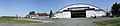
 Letňany airport 01.JPG 3,872 × 2,592; 3.23 MB
-
 Letňany airport 02.JPG 3,872 × 2,592; 3.33 MB
-
 Letňany Prague Airport final aproach.jpg 2,920 × 3,397; 2.51 MB
-
 NPP Letiste Letnany.jpg 1,800 × 1,200; 397 KB
-
 NPP Letiště Letňany - početnost kolonie sysla obecného.pdf 1,533 × 993; 78 KB
-
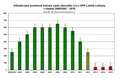
 Vývoj populace sysla obecného v NPP Letiště Letňany.svg 852 × 524; 172 KB
.jpg)


