Category:Leuvebrug (Dordrecht)
Jump to navigation
Jump to search
| Object location | | View all coordinates using: OpenStreetMap |
|---|
bridge in Dordrecht, Netherlands  | |||||
| Upload media | |||||
| Instance of | |||||
|---|---|---|---|---|---|
| Part of | |||||
| Location | Dordrecht, South Holland, Netherlands | ||||
| Street address |
| ||||
| Heritage designation |
| ||||
 | |||||
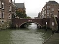
Nederlands: Leuvebrug, Dordrecht
|
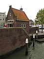
This is a category about rijksmonumentcomplex number 522273
|
Verkeersbrug met beelden van Hildo Krop.
|
This is a category about rijksmonument number 522274
|
Brugwachterswoning
|
This is a category about rijksmonument number 522275
|
| Address |
|
Media in category "Leuvebrug (Dordrecht)"
The following 4 files are in this category, out of 4 total.
-
 Dordrecht Lange Geldersekade1 017 9381.jpg 5,886 × 3,840; 16.86 MB
-
 Dordrecht Leuvebrug.jpg 3,264 × 2,448; 2.03 MB
-
 Leuvebrug Hildo Krop gevangene.JPG 1,944 × 2,592; 1.46 MB
-
 RM522275 Dordrecht - Brugwachtershuisje bij Leuvebrug.jpg 2,448 × 3,264; 1.83 MB


