Category:Leyland, Lancashire
Vai alla navigazione
Vai alla ricerca
town in Lancashire, England  | |||||
| Carica un file multimediale | |||||
| Istanza di | |||||
|---|---|---|---|---|---|
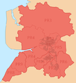
| Luogo | South Ribble, Lancashire, Nord Ovest dell'Inghilterra, Inghilterra | ||||
 | |||||
English: Leyland is a town in the South Ribble borough of Lancashire, England, about six miles (10 Km) south of the city of Preston.
Norsk bokmål: Leyland er en by i Lancashire i England, omkring en mil sør for Preston. Den er administrasjonssenter og største by i distriktet South Ribble.
Română: Leyland este un oraş în comitatul Lancashire, regiunea North West, Anglia. Oraşul se află în districtul South Ribble a cărui reşrdinţă este.
Sottocategorie
Questa categoria contiene le 16 sottocategorie indicate di seguito, su un totale di 16.
A
- St Andrew's Church, Leyland (7 F)
B
E
- Eagle and Child, Leyland (5 F)
J
- St James, Leyland (5 F)
L
- Leyland railway station (22 F)
M
- Midge Hall (7 F)
O
- Old Grammar School, Leyland (4 F)
T
- Tesco Extra, Leyland (5 F)
File nella categoria "Leyland, Lancashire"
Questa categoria contiene 135 file, indicati di seguito, su un totale di 135.
-
 20 to 25 The Orchard - geograph.org.uk - 499859.jpg 640 × 480; 167 KB
-
 78 Towngate, Leyland.jpg 1 200 × 806; 756 KB
-
 A barrowful of pumpkins at Paul's Farm Shop, Leyland - geograph.org.uk - 2135532.jpg 1 600 × 1 200; 541 KB
-

-
 Almshouse Cottages, Leyland.jpg 2 031 × 1 552; 553 KB
-
 Almshouses, Leyland.jpg 4 096 × 1 895; 1,24 MB
-

-
 Arnold Clark Car Dealership, Leyland - geograph.org.uk - 2135521.jpg 1 600 × 1 192; 343 KB
-
-
 Atherton Hall farm - geograph.org.uk - 140727.jpg 640 × 480; 112 KB
-
 Avant Gardens in Leyland - geograph.org.uk - 1576615.jpg 640 × 480; 68 KB
-
 Avant Gardens in Leyland - geograph.org.uk - 1576619.jpg 640 × 480; 71 KB
-
 Back entrance to Worden Park - geograph.org.uk - 1385141.jpg 640 × 468; 112 KB
-
 Baptist Church Leyland - geograph.org.uk - 2626536.jpg 3 648 × 2 736; 2,13 MB
-
 Beech Road, Leyland - geograph.org.uk - 1991701.jpg 2 843 × 2 050; 1,03 MB
-
 Bow Lane, Leyland - geograph.org.uk - 800618.jpg 640 × 480; 210 KB
-
 Brandon Taylorian's grandparents' home.png 1 116 × 629; 1,24 MB
-

-
 Centurion Way, Leyland - geograph.org.uk - 800560.jpg 640 × 480; 237 KB
-
 Chapel Brow, Leyland - geograph.org.uk - 800624.jpg 640 × 480; 181 KB
-
 Church Road, Leyland - geograph.org.uk - 2020455.jpg 2 048 × 1 536; 1,17 MB
-
 Churchill Way, Leyland - geograph.org.uk - 2290101.jpg 640 × 480; 122 KB
-
 Clubhouse - geograph.org.uk - 279622.jpg 640 × 480; 72 KB
-
 Corner of Sumner - panoramio.jpg 2 848 × 2 136; 1,46 MB
-
 Corner of Thurston - panoramio.jpg 2 848 × 2 136; 1,48 MB
-
 Courthouse - geograph.org.uk - 5518086.jpg 2 592 × 1 936; 1,59 MB
-
 Dunkirk Hall, Leyland.jpg 1 200 × 822; 705 KB
-
 Electricity Substation - geograph.org.uk - 1324660.jpg 480 × 640; 86 KB
-
 Entrance to Wellfield High School (geograph 2018758).jpg 2 755 × 1 986; 1,38 MB
-
 Farm and barn - geograph.org.uk - 286182.jpg 640 × 480; 134 KB
-
 Farm buildings, Altcar farm, Leyland - geograph.org.uk - 1384957.jpg 640 × 436; 48 KB
-
 Flush Bracket at Leyland, Holland's Farm.jpg 2 880 × 4 320; 2,32 MB
-
 Flush Bracket at Leyland, Saint Andrew's Church.jpg 2 904 × 3 872; 4,25 MB
-
 Former Police Station (1882) - geograph.org.uk - 800759.jpg 640 × 480; 223 KB
-
 Former St Andrew's School, Leyland.jpg 3 006 × 2 214; 1,19 MB
-
 Former St Mary's Roman Catholic Junior School, Leyland.jpg 4 608 × 3 456; 5,13 MB
-
 Fox Lane, Leyland - geograph.org.uk - 2034699.jpg 2 950 × 2 180; 1,23 MB
-
 Fox Lane, Leyland - geograph.org.uk - 2356853.jpg 3 072 × 2 304; 1,47 MB
-
 Gassy beer here - geograph.org.uk - 118476.jpg 640 × 426; 81 KB
-
 George IV, Towngate Leyland - geograph.org.uk - 911996.jpg 640 × 480; 164 KB
-
 Hall car park, Worden Park - geograph.org.uk - 1385130.jpg 640 × 480; 132 KB
-
 Heald House Road crosses the M6 at Leyland - geograph.org.uk - 2376481.jpg 1 600 × 1 198; 381 KB
-
 Herbert Street, Leyland - geograph.org.uk - 2290090.jpg 640 × 480; 66 KB
-
 Hough Lane, Leyland - geograph.org.uk - 2018777.jpg 2 871 × 2 068; 1,23 MB
-
 Hough Lane, Leyland - geograph.org.uk - 912002.jpg 640 × 480; 167 KB
-
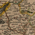 Hundred of Leyland.png 915 × 915; 1,43 MB
-
 King Street at Towngate - geograph.org.uk - 5518065.jpg 2 592 × 1 936; 1,36 MB
-
 Lanchester Park, Leyland - geograph.org.uk - 2280633.jpg 640 × 480; 101 KB
-
 Leyland Conservative Club - geograph.org.uk - 5518078.jpg 2 592 × 1 936; 1,68 MB
-
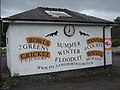 Leyland Cricket Club - geograph.org.uk - 2474732.jpg 1 600 × 1 200; 342 KB
-
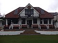 Leyland Cricket Club - Pavilion - geograph.org.uk - 2474735.jpg 1 600 × 1 200; 290 KB
-
 Leyland Cricket Club - Scoreboard - geograph.org.uk - 2474738.jpg 1 600 × 1 200; 333 KB
-
 Leyland Cricket Ground - geograph.org.uk - 2313488.jpg 3 052 × 2 276; 1,17 MB
-
 Leyland fire station - geograph.org.uk - 266761.jpg 640 × 427; 230 KB
-
 Leyland Hotel, Leyland - geograph.org.uk - 1925889.jpg 640 × 480; 62 KB
-
 Leyland indoor market - geograph.org.uk - 2018785.jpg 2 948 × 2 149; 1,3 MB
-
 Leyland Magistrates' Court - geograph.org.uk - 1105934.jpg 640 × 480; 60 KB
-
 Leyland Market - geograph.org.uk - 2804420.jpg 640 × 427; 417 KB
-
 Leyland Methodist Church - geograph.org.uk - 2804496.jpg 640 × 480; 443 KB
-
 Leyland Methodist Church - geograph.org.uk - 2804716.jpg 640 × 480; 363 KB
-
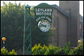
 Leyland Motors Clock - geograph.org.uk - 2804480.jpg 640 × 480; 348 KB
-

-
 Leyland Motors Sculpture - geograph.org.uk - 1511880.jpg 640 × 480; 105 KB
-
 Leyland Police Station - geograph.org.uk - 1105925.jpg 640 × 480; 54 KB
-
 Leyland Police Station - geograph.org.uk - 2088582.jpg 1 196 × 800; 898 KB
-
 Leyland railway Metro-Vickers Co-Bo geograph-2401183-by-Ben-Brooksbank.jpg 2 272 × 1 447; 731 KB
-
 Leyland South post office - geograph.org.uk - 1384922.jpg 640 × 514; 108 KB
-

-
 Leyland unparished area UK locator map.svg 1 425 × 1 038; 355 KB
-
 Leyland War Memorial - geograph.org.uk - 1434835.jpg 640 × 480; 125 KB
-
 Leyprint, Leyland - geograph.org.uk - 2280611.jpg 640 × 480; 121 KB
-
 London to Glasgow Railway - geograph.org.uk - 800764.jpg 640 × 480; 186 KB
-
 Lovely day for Shopping - Leyland - geograph.org.uk - 46066.jpg 640 × 427; 137 KB
-
 Morrison's Leyland - geograph.org.uk - 1389755.jpg 640 × 480; 52 KB
-
 Netto, Towngate, Leyland - geograph.org.uk - 912012.jpg 639 × 455; 140 KB
-
 Old Hall, Balcarres Road, Leyland.jpg 4 608 × 3 456; 5,25 MB
-
 Old Police Station Leyland (1).jpg 1 328 × 1 026; 202 KB
-
 On Towngate at Barristers Pub - geograph.org.uk - 5518073.jpg 2 592 × 1 936; 1,48 MB
-
 Path through Worden Park - geograph.org.uk - 1385149.jpg 640 × 480; 118 KB
-
 Peacock Hall, Leyland.jpg 640 × 480; 136 KB
-
 Perrys, Leyland - geograph.org.uk - 800766.jpg 640 × 480; 225 KB
-
 PR postcode area locator map.png 644 × 702; 74 KB
-
 PR postcode area.png 636 × 693; 92 KB
-
 Preston Urban Area locator map.png 643 × 703; 65 KB
-
 Rose and Crown, Stanifield Lane, Leyland - geograph.org.uk - 800771.jpg 640 × 480; 162 KB
-
 South Ribble Council offices - geograph.org.uk - 1105916.jpg 640 × 480; 55 KB
-
 St Mary's Church, Leyland.jpg 1 200 × 792; 271 KB
-
 St Marys Catholic High School - Leyland (geograph 5681742).jpg 3 264 × 1 836; 2,39 MB
-
 Tapas Bar and Restaurant - geograph.org.uk - 800632.jpg 640 × 480; 221 KB
-
 The "Fox and Lion", Towngate, Leyland - geograph.org.uk - 500118.jpg 640 × 480; 161 KB
-
 The Bobbin Mill - geograph.org.uk - 915946.jpg 640 × 466; 65 KB
-
 The Buckshaw Man - geograph.org.uk - 1511828.jpg 640 × 480; 56 KB
-
 The County Ground - Lancashire FA (geograph 2781984).jpg 4 000 × 3 000; 3,92 MB
-
 The Gables, Hough Lane, Leyland - geograph.org.uk - 912007.jpg 640 × 480; 251 KB
-
 The Leyland Lion - geograph.org.uk - 2804451.jpg 640 × 480; 490 KB
-
 The Queens, Golden Hill Lane, Leyland - geograph.org.uk - 800652.jpg 640 × 480; 235 KB
-
 The Railway, Preston Road, Leyland - geograph.org.uk - 800769.jpg 620 × 464; 156 KB
-
 The Remains of Leyland Motors - geograph.org.uk - 1389761.jpg 640 × 361; 45 KB
-
 The Wheatsheaf Inn, Leyland Lane - geograph.org.uk - 1026695.jpg 612 × 460; 138 KB
-

-
 Up for Sale - geograph.org.uk - 500112.jpg 640 × 480; 173 KB
-
 Weavers' Cottages, Leyland.jpg 2 405 × 1 775; 958 KB
-
 Worden Park - geograph.org.uk - 1385158.jpg 640 × 480; 120 KB
-
 Worden Park, Leyland - geograph.org.uk - 500205.jpg 500 × 360; 215 KB
-
 Worden Sports College - geograph.org.uk - 138983.jpg 600 × 444; 53 KB
-
 Worden Sports College - geograph.org.uk - 138991.jpg 600 × 444; 37 KB
-
 Worden Sports College - geograph.org.uk - 138999.jpg 600 × 444; 46 KB
-
 Worden Sports College - geograph.org.uk - 501324.jpg 500 × 266; 69 KB
-
 Worden Sports College 499079.jpg 500 × 284; 135 KB
-
 Wordensportscollege2.jpg 471 × 287; 26 KB
-
 Balshaw's Grammar School - Leyland - geograph.org.uk - 7668.jpg 640 × 455; 63 KB
-
 Church - geograph.org.uk - 279636.jpg 640 × 480; 86 KB
-
 Cottages beside the B5253 - geograph.org.uk - 107593.jpg 640 × 426; 98 KB
-
 Crown of thorns - geograph.org.uk - 107590.jpg 640 × 426; 89 KB
-
 Derelict farm buildings - geograph.org.uk - 315905.jpg 640 × 427; 98 KB
-
 Dog wash at the car park at Worden Park - geograph.org.uk - 140746.jpg 640 × 480; 126 KB
-
 Fox Lane, Leyland - geograph.org.uk - 500116.jpg 640 × 480; 188 KB
-
 Go North, young man - geograph.org.uk - 118558.jpg 640 × 426; 109 KB
-
 Gone up in the world - geograph.org.uk - 107596.jpg 640 × 426; 124 KB
-
-
 Leyland Motors Clock, Leyland - geograph.org.uk - 500208.jpg 500 × 334; 73 KB
-
 No I don't own part of the company - geograph.org.uk - 497722.jpg 640 × 480; 218 KB
-
 North on the M6 near Nixon Hillock - geograph.org.uk - 118475.jpg 640 × 426; 69 KB
-
 Not quite the right angle - geograph.org.uk - 107601.jpg 640 × 583; 124 KB
-
 Officers' housing for nearby Prisons - geograph.org.uk - 107348.jpg 640 × 360; 82 KB
-
 Old vicarage, Leyland - geograph.org.uk - 266105.jpg 432 × 640; 107 KB
-
 Rural-Urban fringe development - geograph.org.uk - 293445.jpg 640 × 480; 73 KB
-
 The " Old Original Seven Stars", Leyland - geograph.org.uk - 500104.jpg 640 × 480; 154 KB
-
 The "Seven Stars", Leyland - geograph.org.uk - 500105.jpg 640 × 480; 192 KB
-
 Time for a new direction - geograph.org.uk - 118478.jpg 640 × 426; 60 KB
-

-
 Turpin Green, Leyland. - geograph.org.uk - 88479.jpg 640 × 469; 53 KB
-
 Under the London - Glasgow line - geograph.org.uk - 118557.jpg 640 × 426; 87 KB
-
 United Reformed Church, Leyland - geograph.org.uk - 293029.jpg 640 × 480; 245 KB
-
 Weavers' Cottages - geograph.org.uk - 286119.jpg 640 × 480; 81 KB


.jpg)


_-_geograph.org.uk_-_800759.jpg)


.jpg)


.jpg)


.jpg)


_and_the_A581_-_geograph.org.uk_-_107515.jpg)


