Category:Linguistic maps of Mali
Jump to navigation
Jump to search
Countries of Africa: Algeria · Angola · Benin · Burkina Faso · Cameroon · Central African Republic · Chad · Democratic Republic of the Congo · Republic of the Congo · Equatorial Guinea · Eritrea · Ethiopia · Gabon · The Gambia · Ghana · Guinea · Ivory Coast · Kenya · Libya · Mali · Morocco · Namibia · Niger · Nigeria · Senegal · South Africa · Sudan · Tanzania · Togo · Tunisia · Uganda · Zambia
Limited recognition: Ambazonia
Limited recognition: Ambazonia
Media in category "Linguistic maps of Mali"
The following 12 files are in this category, out of 12 total.
-
 Dogon-lg-ru.png 2,996 × 2,124; 166 KB
-
 Grandes-aires-linguistiques-berbères-v2.png 768 × 490; 74 KB
-
 Hassaniya language distribution.svg 457 × 410; 61 KB
-
 Mamara language.png 550 × 623; 96 KB
-
 MandingoMap-1906 with color.png 743 × 477; 493 KB
-
 MandingoMap-1906.jpg 743 × 477; 189 KB
-
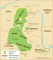
 Map of the Dogon languages.svg 1,300 × 941; 14.14 MB
-
 Map of the Manding language continuum.png 1,308 × 866; 211 KB
-
 Soninke.gif 428 × 308; 27 KB
-
 Supyire language.png 550 × 623; 93 KB
-
 Tawellemmet.svg 400 × 400; 36 KB
-
 Поширення Хасанії.svg 457 × 410; 62 KB


