Category:Llera
Jump to navigation
Jump to search
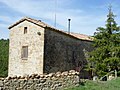
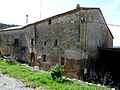
Català: Masia de Llera, a Lladurs (Solsonès)
This is a category about a building indexed in the Catalan heritage register as Bé Cultural d'Interès Local (BCIL) under the reference IPA-17341. |
| Object location | | View all coordinates using: OpenStreetMap |
|---|
masia in Lladurs (Solsonès, Catalonia) _02.jpg) | |||||
| Upload media | |||||
| Instance of | |||||
|---|---|---|---|---|---|
| Location | Lladurs, Solsonès, Lleida Province, Catalonia | ||||
| Street address |
| ||||
| Architectural style | |||||
| Heritage designation |
| ||||
| Inception |
| ||||
| Elevation above sea level |
| ||||
 | |||||
Media in category "Llera"
The following 10 files are in this category, out of 10 total.
-
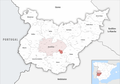 Karte Gemeinde Llera 2022.png 5,000 × 3,534; 1.98 MB
-
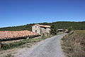 Llera (Lladurs) 01.jpg 3,456 × 2,304; 3.97 MB
-
 Llera (Lladurs) 02.jpg 3,456 × 2,304; 4.04 MB
-
 Llera (Lladurs) 03.jpg 3,456 × 2,304; 4.53 MB
-
 Llera (Lladurs) 04.jpg 3,456 × 2,304; 3.59 MB
-
 LLERA - LLADURS - IB-277.JPG 2,048 × 1,536; 1.55 MB
-
 LLERA - LLADURS - IB-278.JPG 1,536 × 2,048; 1.54 MB
-
 LLERA - LLADURS - IB-279.JPG 1,536 × 2,048; 1.64 MB
-
 LLERA - LLADURS - IB-280.JPG 2,048 × 1,536; 1.65 MB
-
 LLERA - LLADURS - IB-281.JPG 2,048 × 1,536; 1.55 MB

_01.jpg)
_03.jpg)
_04.jpg)


