Category:Location of former Zeche Garenberg
Jump to navigation
Jump to search
| Camera location | | View all coordinates using: OpenStreetMap |
|---|
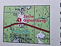
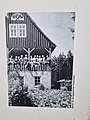
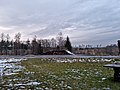
Deutsch: Früherer Standort der oberirdischen Gebäude der Zeche Gahrenberg, durch die Braunkohle im Gahrenberg abgebaut wurde
English: Former location of the buildings for the Gahrenberg coal mine
Media in category "Location of former Zeche Garenberg"
The following 15 files are in this category, out of 15 total.
-
 361 Alte Kohlenstraße, Blick auf den früheren Standort der Zeche Garenberg.jpg 9,248 × 6,936; 16.02 MB
-
 363 Alte Kohlenstraße, Blick auf den früheren Standort der Zeche Garenberg.jpg 9,248 × 6,936; 13.05 MB
-
 364 Informationstafel zur Zeche Garenberg.jpg 9,248 × 6,936; 10.85 MB
-
 365 Informationstafel zur Zeche Garenberg.jpg 9,248 × 6,936; 9.23 MB
-
 366 Informationstafel zur Zeche Garenberg.jpg 6,936 × 9,248; 8.97 MB
-
 367 Informationstafel zur Zeche Garenberg.jpg 6,936 × 9,248; 8.73 MB
-
 368 Informationstafel zur Zeche Garenberg.jpg 9,248 × 6,936; 10.67 MB
-
 369 Informationstafel zur Zeche Garenberg.jpg 9,248 × 6,936; 11.67 MB
-
 370 Informationstafel zur Zeche Garenberg.jpg 9,248 × 6,936; 11.3 MB
-
 371 Informationstafel zur Zeche Garenberg.jpg 6,936 × 9,248; 9.07 MB
-
 372 Informationstafel zur Zeche Garenberg.jpg 384 × 512; 54 KB
-
 373 Früherer Standort der Zeche Garenberg.jpg 9,248 × 6,936; 11.44 MB
-
 375 Früherer Standort der Zeche Garenberg.jpg 9,248 × 6,936; 9.34 MB
-
 378 Früherer Standort der Zeche Garenberg.jpg 9,248 × 6,936; 10.06 MB
-
 379 Früherer Standort der Zeche Garenberg.jpg 9,248 × 6,936; 9.44 MB


