Category:Locator maps of cities in Ventura County, California
Jump to navigation
Jump to search

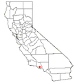
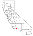
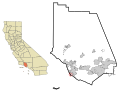
English: Locator maps of cities in Ventura County, Southern California.
- Note: Dual locator types with state reference (tan) & county detail (white) maps — show incorporated municipal boundaries as black lines and currently incorporated areas in gray. A highlighted city or area will appear in red.
- See also wikipedia article (english text): Ventura County, California
Media in category "Locator maps of cities in Ventura County, California"
The following 40 files are in this category, out of 40 total.
-
 CAMap-doton-Camarillo.png 209 × 230; 4 KB
-
 CAMap-doton-Casa Conejo.png 209 × 230; 4 KB
-
 CAMap-doton-Channel Islands Beach.png 209 × 230; 4 KB
-
 CAMap-doton-El Rio.png 209 × 230; 4 KB
-
 CAMap-doton-Fillmore.png 209 × 230; 4 KB
-
 CAMap-doton-La Conchita.png 209 × 230; 4 KB
-
 CAMap-doton-Meiners Oaks.png 209 × 230; 4 KB
-
 CAMap-doton-Mira Monte.png 209 × 230; 4 KB
-
 CAMap-doton-Moorpark.png 209 × 230; 4 KB
-
 CAMap-doton-Oak Park.png 209 × 230; 4 KB
-
 CAMap-doton-Oak View.png 209 × 230; 4 KB
-
 CAMap-doton-Ojai.png 209 × 230; 4 KB
-
 CAMap-doton-Oxnard.PNG 209 × 230; 5 KB
-
 CAMap-doton-Oxnard.png 209 × 230; 4 KB
-
 CAMap-doton-Piru.png 209 × 230; 4 KB
-
 CAMap-doton-Port Hueneme.png 209 × 230; 4 KB
-
 CAMap-doton-Santa Paula.png 209 × 230; 4 KB
-
 CAMap-doton-Simi Valley.PNG 209 × 230; 5 KB
-
 CAMap-doton-Simi Valley.png 209 × 230; 4 KB
-
 CAMap-doton-Thousand Oaks.PNG 209 × 230; 5 KB
-
 CAMap-doton-Thousand Oaks.png 209 × 230; 4 KB
-
 CAMap-doton-Ventura.png 209 × 230; 4 KB
-

-

-

-
-

-

-

-

-

-

-

-

-

-

-

-

-

-


_Highlighted.svg)


