Category:Locator maps of parliamentary constituencies of Gloucestershire
Jump to navigation
Jump to search
Maps of Parliamentary constituencies in Gloucestershire.
Media in category "Locator maps of parliamentary constituencies of Gloucestershire"
The following 19 files are in this category, out of 19 total.
-
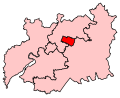 Cheltenham2007Constituency.svg 211 × 171; 120 KB
-
 CheltenhamConstituency.svg 205 × 166; 37 KB
-
 CotswoldConstituency.svg 205 × 166; 37 KB
-
 ForestOfDean2007Constituency.svg 211 × 171; 120 KB
-
 ForestOfDeanConstituency.svg 205 × 166; 37 KB
-
 Gloucester2007Constituency.svg 211 × 171; 120 KB
-
 GloucesterConstituency.svg 205 × 166; 37 KB
-
 Gloucestershire2023Constituencies.svg 512 × 512; 58 KB
-
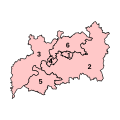
 GloucestershireNumbered.png 200 × 160; 15 KB
-
 GloucestershireParliamentaryConstituencies2007.svg 211 × 171; 75 KB
-
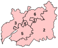 GloucestershireParliamentaryConstituenciesNumbered.svg 205 × 166; 40 KB
-
 NorthCotswolds2023.svg 512 × 512; 57 KB
-
 SouthGloucestershire1974Constituency.svg 96 × 100; 20 KB
-
 Stroud2007Constituency.svg 211 × 171; 120 KB
-
 StroudConstituency.svg 205 × 166; 37 KB
-
 Tewkesbury2007Constituency.svg 211 × 171; 120 KB
-
 TewkesburyConstituency.svg 205 × 166; 37 KB
-
 TheCotswolds2007Constituency.svg 211 × 171; 120 KB
-
 WestGloucestershire1983Constituency.svg 79 × 66; 7 KB


