Category:Lucung Bridge and River (Concepcion, Tarlac)
Jump to navigation
Jump to search
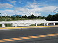
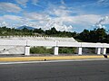
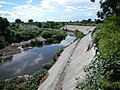
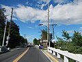
Lucung Bridge K0120+291 Lucung River reconstructed under the US-RP Aid. Lucung River a stream and with estimate terrain elevation above seal level is 32 metres Latitude: 15°19'18.84" Longitude: 120°40'43.85" in Barangay Santo Cristo, Concepcion, Tarlac all along the La Paz-Concepcion, Tarlac Road or Highway.
Media in category "Lucung Bridge and River (Concepcion, Tarlac)"
The following 27 files are in this category, out of 27 total.
-
 1744jfSan Nicolas Bridge Jose Welcome Concepcion Tarlacfvf 01.JPG 4,608 × 3,456; 5.84 MB
-
 1744jfSan Nicolas Bridge Jose Welcome Concepcion Tarlacfvf 02.JPG 4,608 × 3,456; 5.93 MB
-
 1744jfSan Nicolas Bridge Jose Welcome Concepcion Tarlacfvf 03.JPG 3,456 × 4,608; 6.1 MB
-
 1744jfSan Nicolas Bridge Jose Welcome Concepcion Tarlacfvf 04.JPG 4,608 × 3,456; 5.99 MB
-
 1744jfSan Nicolas Bridge Jose Welcome Concepcion Tarlacfvf 05.JPG 3,456 × 4,608; 6.24 MB
-
 1744jfSan Nicolas Bridge Jose Welcome Concepcion Tarlacfvf 06.JPG 4,608 × 3,456; 6.41 MB
-
 1744jfSan Nicolas Bridge Jose Welcome Concepcion Tarlacfvf 07.JPG 4,608 × 3,456; 6.46 MB
-
 1744jfSan Nicolas Bridge Jose Welcome Concepcion Tarlacfvf 09.JPG 4,608 × 3,456; 6.49 MB
-
 1744jfSan Nicolas Bridge Jose Welcome Concepcion Tarlacfvf 10.JPG 4,608 × 3,456; 6.51 MB
-
 1744jfSan Nicolas Bridge Jose Welcome Concepcion Tarlacfvf 11.JPG 4,608 × 3,456; 6.24 MB
-
 1744jfSan Nicolas Bridge Jose Welcome Concepcion Tarlacfvf 12.JPG 4,608 × 3,456; 6.54 MB
-
 1744jfSan Nicolas Bridge Jose Welcome Concepcion Tarlacfvf 13.JPG 4,608 × 3,456; 6.42 MB
-
 1744jfSan Nicolas Bridge Jose Welcome Concepcion Tarlacfvf 14.JPG 4,608 × 3,456; 6.73 MB
-
 1744jfSan Nicolas Bridge Jose Welcome Concepcion Tarlacfvf 15.JPG 4,608 × 3,456; 6.43 MB
-
 1744jfSan Nicolas Bridge Jose Welcome Concepcion Tarlacfvf 16.JPG 4,608 × 3,456; 6.48 MB
-
 1744jfSan Nicolas Bridge Jose Welcome Concepcion Tarlacfvf 17.JPG 4,608 × 3,456; 6.48 MB
-
 1744jfSan Nicolas Bridge Jose Welcome Concepcion Tarlacfvf 18.JPG 4,608 × 3,456; 6.8 MB
-
 1744jfSan Nicolas Bridge Jose Welcome Concepcion Tarlacfvf 19.JPG 3,456 × 4,608; 6.58 MB
-
 1744jfSan Nicolas Bridge Jose Welcome Concepcion Tarlacfvf 20.JPG 4,608 × 3,456; 6.49 MB
-
 1744jfSan Nicolas Bridge Jose Welcome Concepcion Tarlacfvf 21.JPG 4,608 × 3,456; 6.84 MB
-
 1744jfSan Nicolas Bridge Jose Welcome Concepcion Tarlacfvf 22.JPG 3,456 × 4,608; 6.75 MB
-
 1744jfSan Nicolas Bridge Jose Welcome Concepcion Tarlacfvf 23.JPG 3,456 × 4,608; 6.83 MB
-
 1744jfSan Nicolas Bridge Jose Welcome Concepcion Tarlacfvf 24.JPG 4,608 × 3,456; 7.13 MB
-
 1744jfSan Nicolas Bridge Jose Welcome Concepcion Tarlacfvf 25.JPG 4,608 × 3,456; 6.88 MB
-
 1744jfSan Nicolas Bridge Jose Welcome Concepcion Tarlacfvf 26.JPG 3,456 × 4,608; 6.69 MB
-
 1744jfSan Nicolas Bridge Jose Welcome Concepcion Tarlacfvf 27.JPG 4,608 × 3,456; 6.83 MB
-
 1744jfSan Nicolas Bridge Jose Welcome Concepcion Tarlacfvf 28.JPG 4,608 × 3,456; 6.96 MB


