Category:Lutheran church in Czechowice-Dziedzice
Jump to navigation
Jump to search
| Object location | | View all coordinates using: OpenStreetMap |
|---|
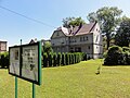
church building in Czechowice-Dziedzice, Poland  | |||||
| Upload media | |||||
| Instance of | |||||
|---|---|---|---|---|---|
| Location | Czechowice-Dziedzice, Gmina Czechowice-Dziedzice, Bielsko County, Silesian Voivodeship, Poland | ||||
 | |||||
Media in category "Lutheran church in Czechowice-Dziedzice"
The following 2 files are in this category, out of 2 total.
-
 POL Czechowice-Dziedzice Zbór EA 1.JPG 3,200 × 2,400; 2.57 MB
-
 POL Czechowice-Dziedzice Zbór EA 2.JPG 3,648 × 2,736; 4.16 MB
