Category:Luxeroth
Jump to navigation
Jump to search
| Object location | | View all coordinates using: OpenStreetMap |
|---|
human settlement  | |||||
| Upload media | |||||
| Instance of | |||||
|---|---|---|---|---|---|
| Location | Attert, Arrondissement of Arlon, Luxembourg, Walloon Region, Belgium | ||||
 | |||||
Media in category "Luxeroth"
This category contains only the following file.
-
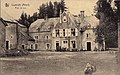 Attert - Luxeroth - Ancienne.jpg 818 × 509; 129 KB