Category:Lysolphturm (Köln)
Jump to navigation
Jump to search
| Object location | | View all coordinates using: OpenStreetMap |
|---|
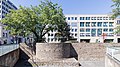
part of roman fortifications of Cologne .jpg) | |||||
| Upload media | |||||
| Instance of | |||||
|---|---|---|---|---|---|
| Location | Cologne-Innenstadt, Cologne, Cologne Government Region, North Rhine-Westphalia, Germany | ||||
 | |||||
Media in category "Lysolphturm (Köln)"
The following 8 files are in this category, out of 8 total.
-
 Köln Röm. Stadtmauer Lysolphturm 01.jpg 3,008 × 2,000; 4.89 MB
-
 Köln-Nordmauer-Lysolphturm-036.JPG 2,048 × 1,536; 1.59 MB
-
 Lysolphturm Köln (1).jpg 2,048 × 1,536; 1.55 MB
-
 Lysolphturm Köln (2).jpg 2,048 × 1,536; 1.64 MB
-
 Lysolphturm Köln-0478.jpg 5,908 × 3,323; 15.76 MB
-
 Lysolphturm Köln-0479.jpg 6,498 × 3,655; 20.2 MB
-
 Lysolphturm, Köln-0872.jpg 6,720 × 3,780; 21.84 MB
-
 Stadtmauer Wehrturm Koeln2007.jpg 1,600 × 1,200; 637 KB


.jpg)


