Category:Maps and plans of Miletus and region
Jump to navigation
Jump to search
More or less detailed maps of the town and region.
Media in category "Maps and plans of Miletus and region"
The following 18 files are in this category, out of 18 total.
-
 Map of Lydia ancient times2-es.svg 2,137 × 1,459; 3.02 MB
-
 Carte des 5 dèmes de Milet.jpg 2,235 × 1,645; 961 KB
-
 Carte des environs de Palatsha - Choiseul-gouffier Gabriel Florent Auguste De - 1782.jpg 2,000 × 1,338; 978 KB
-
 Colonies of Miletus-es.svg 695 × 466; 985 KB
-
 Colonies of Miletus.svg 695 × 466; 497 KB
-
 D307-Territoire de Milet.-L2-Ch8.png 1,454 × 1,624; 260 KB
-
 Didyma Map.jpg 7,183 × 5,564; 750 KB
-
 Map of Archaic Milet Ukr.png 1,000 × 1,133; 55 KB
-
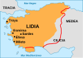 Map of Lydia ancient times-es.svg 868 × 600; 62 KB
-
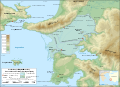
 Milet Asia Minor.png 708 × 618; 177 KB
-
 Mileti vicinia variis temporibus - Choiseul-gouffier Gabriel Florent Auguste De - 1782.jpg 2,000 × 1,338; 1.01 MB
-
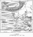
 Miletus Bay silting evolution map-en.svg 1,857 × 1,349; 1.54 MB
-
 Miletus Bay silting evolution map-es.svg 1,857 × 1,349; 1.45 MB
-
 Miletus Bay silting evolution map-fr.svg 1,857 × 1,349; 1.55 MB
-
 Miletus Bay silting evolution map-ru.svg 1,857 × 1,349; 1.55 MB
-
 Miletus map.jpg 1,579 × 677; 809 KB
-
 Palatsa.jpg 3,482 × 2,670; 1.85 MB
-
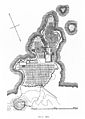 Plan of Miletus in A. Gerkan's Griechische Stadteanlagen Wellcome M0009549.jpg 2,883 × 4,052; 2.31 MB


