Category:Maps by the Instituto Geográfico Nacional (Argentina)
Jump to navigation
Jump to search
Media in category "Maps by the Instituto Geográfico Nacional (Argentina)"
The following 77 files are in this category, out of 77 total.
-
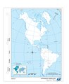
 Continente americano, 1953.jpg 1,188 × 1,740; 916 KB
-
 Mapa político bicontinental de Argentina.jpg 5,906 × 9,449; 3.67 MB
-
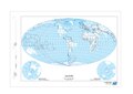
 Mapamundi argentino 2016.jpg 5,265 × 2,851; 5.22 MB
-

-
-
-
-
-
-

-

-
-
-

-
-
-

-

-

-
-

-

-

-
-
-

-
-
-

-

-

-
-

-

-

-
-

-

-

-
-
-

-

-
-

-

-

-
-

-

-

-
-

-

-

-
-

-

-

-
-

-

-

-
-

-

-

-
-

-

-
-
-

-
-
-

-
 República Argentina, 1953.jpg 1,183 × 1,729; 897 KB


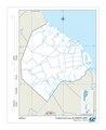
_-_Ciudad_Aut%C3%B3noma_de_Buenos_Aires_-_F%C3%ADsico_(2016).jpg)
_-_Ciudad_Aut%C3%B3noma_de_Buenos_Aires_-_Pol%C3%ADtico_(2016).jpg)
_-_Ciudad_Aut%C3%B3noma_de_Buenos_Aires_-_Satelital_(2016).jpg)
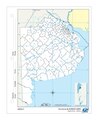
_-_Provincia_de_Buenos_Aires_-_F%C3%ADsico_(2016).jpg)
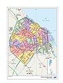
_-_Provincia_de_Buenos_Aires_-_Pol%C3%ADtico_(2016).jpg)
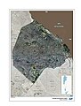
_-_Provincia_de_Buenos_Aires_-_Satelital_(2016).jpg)
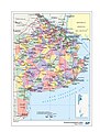
_-_Provincia_de_Catamarca_-_F%C3%ADsico_(2016).jpg)
_-_Provincia_de_Catamarca_-_Pol%C3%ADtico_(2016).jpg)
_-_Provincia_de_Catamarca_-_Satelital_(2016).jpg)
_-_Provincia_de_Corrientes_-_F%C3%ADsico_(2016).jpg)
_-_Provincia_de_Corrientes_-_Pol%C3%ADtico_(2016).jpg)
_-_Provincia_de_Corrientes_-_Satelital_(2016).jpg)
_-_Provincia_de_C%C3%B3rdoba_-_F%C3%ADsico_(2016).jpg)
_-_Provincia_de_C%C3%B3rdoba_-_Pol%C3%ADtico_(2016).jpg)
_-_Provincia_de_C%C3%B3rdoba_-_Satelital_(2016).jpg)
_-_Provincia_de_Entre_R%C3%ADos_-_F%C3%ADsico_(2016).jpg)
_-_Provincia_de_Entre_R%C3%ADos_-_Pol%C3%ADtico_(2016).jpg)
_-_Provincia_de_Entre_R%C3%ADos_-_Satelital_(2016).jpg)
_-_Provincia_de_Formosa_-_F%C3%ADsico_(2016).jpg)
_-_Provincia_de_Formosa_-_Pol%C3%ADtico_(2016).jpg)
_-_Provincia_de_Formosa_-_Satelital_(2016).jpg)
_-_Provincia_de_Jujuy_-_Fisico_(2016).jpg)
_-_Provincia_de_Jujuy_-_Pol%C3%ADtico_(2016).jpg)
_-_Provincia_de_Jujuy_-_Satelital_(2016).jpg)
_-_Provincia_de_La_Pampa_-_F%C3%ADsico_(2016).jpg)
_-_Provincia_de_La_Pampa_-_Pol%C3%ADtico_(2016).jpg)
_-_Provincia_de_La_Pampa_-_Satelital_(2016).jpg)
_-_Provincia_de_La_Rioja_-_F%C3%ADsico_(2016).jpg)
_-_Provincia_de_La_Rioja_-_Pol%C3%ADtico_(2016).jpg)
_-_Provincia_de_La_Rioja_-_Satelital_(2016).jpg)
_-_Provincia_de_Mendoza_-_F%C3%ADsico_(2016).jpg)
_-_Provincia_de_Mendoza_-_Pol%C3%ADtico_(2016).jpg)
_-_Provincia_de_Mendoza_-_Satelital_(2016).jpg)
_-_Provincia_de_Misiones_-_F%C3%ADsico_(2016).jpg)
_-_Provincia_de_Misiones_-_Pol%C3%ADtico_(2016).jpg)
_-_Provincia_de_Misiones_-_Satelital_(2016).jpg)
_-_Provincia_de_Neuqu%C3%A9n_-_F%C3%ADsico_(2016).jpg)
_-_Provincia_de_Neuqu%C3%A9n_-_Pol%C3%ADtico_(2016).jpg)
_-_Provincia_de_Neuqu%C3%A9n_-_Satelital_(2016).jpg)
_-_Provincia_de_R%C3%ADo_Negro_-_F%C3%ADsico_(2016).jpg)
_-_Provincia_de_R%C3%ADo_Negro_-_Pol%C3%ADtico_(2016).jpg)
_-_Provincia_de_R%C3%ADo_Negro_-_Satelital_(2016).jpg)
_-_Provincia_del_Chaco_-_F%C3%ADsico_(2016).jpg)
_-_Provincia_del_Chaco_-_Pol%C3%ADtico_(2016).jpg)
_-_Provincia_del_Chaco_-_Satelital_(2016).jpg)
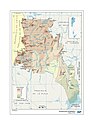
_-_Provincia_del_Chubut_-_F%C3%ADsico_(2016).jpg)
_-_Provincia_del_Chubut_-_Pol%C3%ADtico_(2017).jpg)
_-_Provincia_del_Chubut_-_Satelital_(2016).jpg)
