Category:Maps of Albania during World War II
Jump to navigation
Jump to search
Countries of Europe: Albania · Belarus · Belgium · Bosnia and Herzegovina · Bulgaria · France‡ · Germany · Hungary · Latvia · Lithuania · Luxembourg · Montenegro · Netherlands‡ · Poland · Serbia
Media in category "Maps of Albania during World War II"
The following 50 files are in this category, out of 50 total.
-
 Albania 1913-1941.png 467 × 804; 400 KB
-
 Albania Greek occupation.png 330 × 355; 17 KB
-
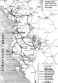 Albania road map construction under Italian occupation 1939-1943.png 477 × 683; 232 KB
-
 2차 대전 기간 알바니아의 지도.png 647 × 839; 115 KB
-
 Map of Albania during Worl War 2.png 647 × 839; 156 KB
-
 Map of Albania during WWII-CS.png 1,005 × 1,305; 281 KB
-
 Map of Albania during WWII-IT.png 1,030 × 1,306; 292 KB
-
 Map of Albania during WWII-SQ.png 643 × 839; 158 KB
-
 Map of Albania during WWII.png 647 × 839; 187 KB
-
 GranAlbania 1941-hu.svg 1,725 × 2,115; 243 KB
-
 GranAlbania1941 sr.svg 1,725 × 2,115; 185 KB
-
 GranAlbania1941.svg 1,725 × 2,115; 466 KB
-
 KingdomOfAlbania1941.png 1,698 × 3,000; 870 KB
-
 KingdomOfAlbania1943.png 2,300 × 3,700; 948 KB
-
 Albanian Kingdom (1939).svg 450 × 456; 452 KB
-
 Albanian Kingdom (1942).svg 450 × 456; 500 KB
-
 AtlBalk1940.jpg 318 × 327; 146 KB
-
 AtlBalk1942.jpg 318 × 327; 141 KB
-
 Balcans 1942.png 651 × 698; 86 KB
-
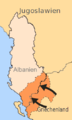
 Besatzungsgebiete-Alb.png 330 × 355; 22 KB
-
 Bulgaria 1944 WWII svg.png 266 × 329; 49 KB
-
 Greek Offensive 1940 41 in Northern Epirus el.svg 1,097 × 844; 766 KB
-
 Greek Offensive 1940 41 in Northern Epirus-2-es.svg 1,097 × 844; 1.06 MB
-
 Greek Offensive 1940 41 in Northern Epirus-2.svg 1,097 × 844; 1.06 MB
-
 Greek Offensive 1940 41 in Northern Epirus.svg 1,097 × 844; 769 KB
-
 Greek Offensive Epirus-2-hu.svg 1,097 × 844; 1.06 MB
-
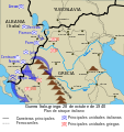
 Griechische Gegenoffensive.png 300 × 500; 50 KB
-
 Griechische-Offensive-1.jpg 330 × 355; 73 KB
-
 Griechische-Offensive-3.png 330 × 355; 19 KB
-
 Griechische-Offensive11.png 330 × 355; 20 KB
-
 GuerraItaloGriega28101940.svg 1,052 × 1,116; 178 KB
-
 Kosovo 1913-1992 CIA.jpg 978 × 827; 296 KB
-
 Kosovo 1941-sr.png 663 × 772; 48 KB
-
 Kosovo 1941.png 663 × 772; 54 KB
-
 Map of Kosovo during WW II.png 783 × 524; 97 KB
-
 Map of Vardar Macedonia during WW II.png 814 × 666; 135 KB
-
 Ndarja administrative e Tokave të Liruara.svg 2,073 × 3,543; 1.25 MB
-
 OcupaciónGriegaDeAlbania 1940-1941-hu.svg 1,700 × 1,700; 149 KB
-
 OcupaciónGriegaDeAlbania19401941.svg 1,700 × 1,700; 235 KB
-
 Responsability zones Mac WW II.jpg 517 × 395; 58 KB
-
 Srbsko WWII es.svg 804 × 1,124; 313 KB
-
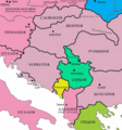
 Western Balkans 1942-2008-hu.svg 1,222 × 930; 248 KB
-
 Western Balkans 1942.2008 (ru).png 900 × 675; 338 KB
-
 Western Balkans 1942.2008 (ru).svg 1,200 × 900; 298 KB
-
 Western Balkans 1942.2008 ca.svg 1,222 × 930; 246 KB
-
 Western Balkans 1942.2008 ES.svg 1,222 × 930; 543 KB
-
 Western Balkans 1942.2008 sr.svg 1,200 × 900; 298 KB
-
 Western Balkans 1942.2008.png 800 × 600; 292 KB
-
 WorldWarIILocationMapAL.png 630 × 766; 23 KB
-
 Ελληνοϊταλικός Πόλεμος 28101940.svg 1,052 × 1,116; 178 KB


.svg)
.svg)


.png)
.svg)


