Category:Maps of Basel prince-bishopric
Jump to navigation
Jump to search
Deutsch: Diese Kategorie enthält Abbildungen von Landkarten mit dem Gebiet des Fürstbistums Basel und/oder des alten (vor 1828) Bistums Basel. Das Gebiet über das der Bischof die weltliche Landeshoheit hatte, wich deutlich von jenem der kirchlichen Diözese Basel ab.
English: This category includes maps of the Prince-Bishopric of Basel and/or the old (before 1828) ecclesiastical diocese of Basel.
Media in category "Maps of Basel prince-bishopric"
The following 12 files are in this category, out of 12 total.
-
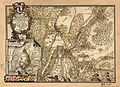
 Fuerstbistum Basel 16Jh.png 1,500 × 1,174; 237 KB
-
 Bistum-Basel2.png 2,500 × 1,956; 898 KB
-
 Ausdehnung Bistum Basel korr.JPG 865 × 1,049; 120 KB
-
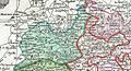 Basle Bishopric and Canton 18th century.jpg 1,024 × 556; 474 KB
-
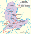
 Bistum Basel im 15. Jahrhundert.png 780 × 833; 83 KB
-
 Bistum Basel im 15. Jahrhundert0105a.png 780 × 833; 102 KB
-
 Burgunderkriege.png 2,500 × 2,527; 1.13 MB
-
 Droysens-25g.jpg 5,661 × 4,307; 4.61 MB
-
 Gemarkungskarte der bischöflich-baslerischen Dörfer um Schliengen 1763.jpg 4,725 × 3,429; 5.59 MB
-
 HRE Dioceses Prince-Bishoprics, c. 1780.jpg 1,013 × 1,294; 337 KB
-
 Landvogtei Schliengen.png 597 × 900; 173 KB
-
 Map bishopric Basel 1444.jpg 4,683 × 5,990; 7.43 MB


