Category:Maps of Bergh
Jump to navigation
Jump to search
Wikimedia category | |||||
| Upload media | |||||
| Instance of | |||||
|---|---|---|---|---|---|
| Category combines topics | |||||
| Bergh | |||||
former municipality in Gelderland, the Netherlands   | |||||
| Instance of |
| ||||
| Named after |
| ||||
| Location |
| ||||
| Population |
| ||||
| Replaces |
| ||||
 | |||||
Media in category "Maps of Bergh"
The following 3 files are in this category, out of 3 total.
-
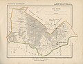 's-Heerenberg, Gemeenteatlas van Nederland.jpg 2,773 × 2,154; 5.2 MB
-
 Locator map of Bergh.png 280 × 140; 9 KB
-
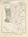 Zeddam, Gemeenteatlas van Nederland.jpg 1,612 × 2,150; 4.27 MB


