Category:Maps of Free State municipalities with 2016 borders
Jump to navigation
Jump to search
This category contains maps of municipalities in the Free State province of South Africa that show the the municipal borders as they are after the municipal election of 3 August 2016. This is the most recent demarcation.
Media in category "Maps of Free State municipalities with 2016 borders"
The following 33 files are in this category, out of 33 total.
-
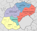
 Map of the Free State with districts labelled (2016).svg 828 × 693; 703 KB
-
 Map of the Free State with municipalities blank (2016).svg 828 × 693; 1.15 MB
-
 Blank map of the Free State (2016).svg 749 × 667; 613 KB
-
 Map of the Free State with Dihlabeng highlighted (2016).svg 828 × 693; 655 KB
-
 Map of South Africa with Fezile Dabi highlighted (2016).svg 809 × 709; 719 KB
-
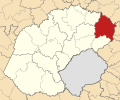
 Map of the Free State with Fezile Dabi highlighted (2016).svg 828 × 693; 682 KB
-
 Map of the Free State with Kopanong highlighted (2016).svg 828 × 693; 664 KB
-
 Map of South Africa with Lejweleputswa highlighted (2016).svg 809 × 709; 720 KB
-
 Map of the Free State with Lejweleputswa highlighted (2016).svg 828 × 693; 684 KB
-
 Map of the Free State with Letsemeng highlighted (2016).svg 828 × 693; 656 KB
-
 Map of the Free State with Mafube highlighted (2016).svg 828 × 693; 653 KB
-
 Map of the Free State with Maluti-a-Phofung highlighted (2016).svg 828 × 693; 652 KB
-
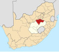
 Map of South Africa with Mangaung highlighted (2016).svg 809 × 709; 711 KB
-
 Map of the Free State with Mangaung highlighted (2016).svg 828 × 693; 659 KB
-
 Map of the Free State with Mantsopa highlighted (2016).svg 828 × 693; 653 KB
-

-
-
 Map of the Free State with Masilonyana highlighted (2016).svg 828 × 693; 654 KB
-
 Map of the Free State with Matjhabeng highlighted (2016).svg 828 × 693; 651 KB
-
 Map of the Free State with Metsimaholo highlighted (2016).svg 828 × 693; 652 KB
-
 Map of the Free State with Mohokare highlighted (2016).svg 828 × 693; 664 KB
-
 Map of the Free State with Moqhaka highlighted (2016).svg 828 × 693; 662 KB
-
 Map of the Free State with Nala highlighted (2016).svg 828 × 693; 655 KB
-
 Map of the Free State with Ngwathe highlighted (2016).svg 828 × 693; 653 KB
-
 Map of the Free State with Nketoana highlighted (2016).svg 828 × 693; 653 KB
-
 Map of the Free State with Phumelela highlighted (2016).svg 828 × 693; 666 KB
-
 Map of the Free State with Setsoto highlighted (2016).svg 828 × 693; 657 KB
-
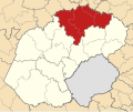
 Map of South Africa with Thabo Mofutsanyana highlighted (2016).svg 809 × 709; 724 KB
-
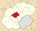
 Map of the Free State with Thabo Mofutsanyana highlighted (2016).svg 828 × 693; 698 KB
-
 Map of the Free State with Tokologo highlighted (2016).svg 828 × 693; 655 KB
-
 Map of the Free State with Tswelopele highlighted (2016).svg 828 × 693; 655 KB
-
 Map of South Africa with Xhariep highlighted (2016).svg 809 × 709; 721 KB
-
 Map of the Free State with Xhariep highlighted (2016).svg 828 × 693; 691 KB
.svg)
.svg)
.svg)
.svg)
.svg)
.svg)
.svg)
.svg)
.svg)
.svg)
.svg)
.svg)
.svg)
.svg)
.svg)
.svg)
.svg)
.svg)
.svg)
.svg)
.svg)
.svg)
.svg)
.svg)
.svg)
.svg)
.svg)
.svg)
.svg)
.svg)
.svg)
.svg)
.svg)