Category:Maps of Goa by Linschoten
Jump to navigation
Jump to search
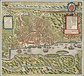
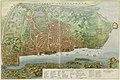
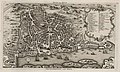
English: This often reproduced map of Goa was designed by Jan Huygen van Linschoten in 1595 and etched by graveur Baptista van Doetecum. The category also includes later maps by other cartographers who clearly used the same design and perspective; including in chronological order (to be indicated in each map): Matthäus Merian, Philip Baldaeus, Johannes Vingboons and Jacques-Nicolas Bellin.
Media in category "Maps of Goa by Linschoten"
The following 17 files are in this category, out of 17 total.
-

-

-

-

-
 The Island and City of Metropolitan Goa of India WDL22.png 1,277 × 1,024; 2.7 MB
-

-
 AMH-6577-KB Bird's eye view of the city of Goa.jpg 2,400 × 1,681; 1.24 MB
-

-
-
 Another reproduction of Map of Goa was published *by M. Merian, 1646 detail.jpg 1,185 × 803; 160 KB
-
 Another reproduction of Map of Goa was published *by M. Merian, 1646.jpg 1,083 × 907; 132 KB
-
 AMH-6152-NA Map of the city of Goa.jpg 8,272 × 5,504; 3.66 MB
-
 This map (with modern hand coloring) from Philip Baldaeus's work.jpg 800 × 645; 140 KB
-
 Bellin's plan of Goa, c.1750;.jpg 800 × 479; 81 KB
-
 "Plan de Goa", in Histoire générale des voyages,1750.jpg 5,707 × 3,339; 1.77 MB
-
 Bellin's plan of Goa, c.1750 VERY LARGE SCAN.jpg 4,432 × 2,656; 1.88 MB
-
 GoaIndiaeOrientalisMetropolis.jpg 2,751 × 2,048; 3.85 MB


_from_Philip_Baldaeus%27s_work.jpg)


