Category:Maps of Gourdon (Lot)
Jump to navigation
Jump to search
Wikimedia category | |||||
| Upload media | |||||
| Instance of | |||||
|---|---|---|---|---|---|
| Category combines topics | |||||
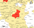
| Gourdon | |||||
commune in Lot, France _Gourdon_vers_le_sud.jpg) .svg) _OSM_01.png) | |||||
| Instance of | |||||
| Location |
| ||||
| Population |
| ||||
| Area |
| ||||
| Elevation above sea level |
| ||||
| Different from | |||||
| official website | |||||
 | |||||
Media in category "Maps of Gourdon (Lot)"
The following 13 files are in this category, out of 13 total.
-
 46 LOT carte grille communale densite INSEE.png 3,507 × 2,480; 3.11 MB
-
 46-AAV2020-Gourdon.png 3,519 × 3,197; 2.11 MB
-
 46-Gourdon-AAV2020.png 3,519 × 2,930; 1.41 MB
-
 46127-Gourdon-argile.png 3,057 × 2,480; 5.27 MB
-
 46127-Gourdon-Natura2000b.png 5,846 × 4,133; 13.23 MB
-
 46127-Gourdon-Routes-Hydro.png 3,507 × 2,480; 3.36 MB
-
 46127-Gourdon-Sols.png 7,015 × 4,960; 9.24 MB
-
 46127-Gourdon-ZNIEFF1.jpg 3,519 × 2,480; 1,011 KB
-
 46127-Gourdon-ZNIEFF2.png 3,519 × 2,480; 7.72 MB
-
 Gourdon (Lot) OSM 01.png 437 × 437; 145 KB
-
 Gourdon (Lot) OSM 02.png 437 × 437; 270 KB
-
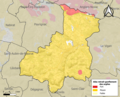
 Map commune FR insee code 46127.png 756 × 605; 87 KB
-
 Mapa de Gourdon (Departamento de Lot).svg 1,012 × 973; 150 KB


_OSM_02.png)

.svg)