Category:Maps of Lee County, Illinois
Jump to navigation
Jump to search
Counties of Illinois: Adams · Alexander · Bond · Boone · Brown · Bureau · Calhoun · Carroll · Cass · Champaign · Christian · Clark · Clay · Clinton · Coles · Cook · Crawford · Cumberland · DeKalb · DeWitt · Douglas · DuPage · Edgar · Edwards · Effingham · Fayette · Ford · Franklin · Fulton · Gallatin · Greene · Grundy · Hamilton · Hancock · Hardin · Henderson · Henry · Iroquois · Jackson · Jasper · Jefferson · Jersey · Jo Daviess · Johnson · Kane · Kankakee · Kendall · Knox · Lake · LaSalle · Lawrence · Lee · Livingston · Logan · Macon · Macoupin · Madison · Marion · Marshall · Mason · Massac · McDonough · McHenry · McLean · Menard · Mercer · Monroe · Montgomery · Morgan · Moultrie · Ogle · Peoria · Perry · Piatt · Pike · Pope · Pulaski · Putnam · Randolph · Richland · Rock Island · St. Clair · Saline · Sangamon · Schuyler · Scott · Shelby · Stark · Stephenson · Tazewell · Union · Vermilion · Wabash · Warren · Washington · Wayne · White · Whiteside · Will · Williamson · Winnebago · Woodford
Wikimedia category | |||||
| Upload media | |||||
| Instance of | |||||
|---|---|---|---|---|---|
| Category combines topics | |||||
| Lee County | |||||
county in Illinois, United States .jpg)  | |||||
| Instance of | |||||
| Named after | |||||
| Location | Illinois | ||||
| Capital | |||||
| Inception |
| ||||
| Population |
| ||||
| Area |
| ||||
| Different from | |||||
| official website | |||||
 | |||||
Subcategories
This category has only the following subcategory.
Media in category "Maps of Lee County, Illinois"
The following 50 files are in this category, out of 50 total.
-
 Dixon Illinois 1919 Automobile Blue Book.jpg 681 × 523; 93 KB
-
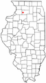
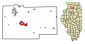
 ILMap-doton-Amboy.PNG 167 × 300; 24 KB
-
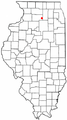
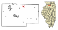
 ILMap-doton-Compton.PNG 167 × 300; 24 KB
-
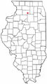
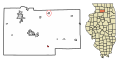
 ILMap-doton-Dixon.PNG 167 × 300; 24 KB
-
 ILMap-doton-FranklinGrove.PNG 167 × 300; 24 KB
-
 ILMap-doton-Harmon.PNG 167 × 300; 24 KB
-
 ILMap-doton-Lee.PNG 167 × 300; 24 KB
-
 ILMap-doton-Nelson.PNG 167 × 300; 24 KB
-
 ILMap-doton-PawPaw.PNG 167 × 300; 24 KB
-
 ILMap-doton-Steward.PNG 167 × 300; 24 KB
-
 ILMap-doton-Sublette.PNG 167 × 300; 24 KB
-
 ILMap-doton-WestBrooklyn.PNG 167 × 300; 24 KB
-
 Lee County Blank.PNG 522 × 326; 7 KB
-
 Lee County Illinois 1839.png 288 × 405; 10 KB
-
-
-

-

-

-

-

-

-

-

-
-

-
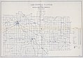 Lee County, Illinois showing rural delivery service LOC 2008627965.jpg 17,823 × 12,542; 25.67 MB
-
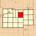
 Map highlighting Alto Township, Lee County, Illinois.svg 512 × 512; 43 KB
-
 Map highlighting Amboy Township, Lee County, Illinois.svg 512 × 512; 50 KB
-
 Map highlighting Ashton Township, Lee County, Illinois.svg 512 × 512; 57 KB
-
 Map highlighting Bradford Township, Lee County, Illinois.svg 512 × 512; 64 KB
-
 Map highlighting Brooklyn Township, Lee County, Illinois.svg 512 × 512; 72 KB
-
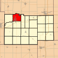 Map highlighting Dixon Township, Lee County, Illinois.svg 512 × 512; 82 KB
-
 Map highlighting East Grove Township, Lee County, Illinois.svg 512 × 512; 86 KB
-
 Map highlighting Franklin Grove Township, Lee County, Illinois.svg 768 × 768; 198 KB
-
 Map highlighting Hamilton Township, Lee County, Illinois.svg 512 × 512; 92 KB
-
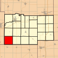
 Map highlighting Harmon Township, Lee County, Illinois.svg 512 × 512; 99 KB
-
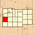
 Map highlighting Lee Center Township, Lee County, Illinois.svg 512 × 512; 107 KB
-
 Map highlighting Marion Township, Lee County, Illinois.svg 512 × 512; 114 KB
-
 Map highlighting May Township, Lee County, Illinois.svg 512 × 512; 121 KB
-
 Map highlighting Nachusa Township, Lee County, Illinois.svg 512 × 512; 129 KB
-
 Map highlighting Nelson Township, Lee County, Illinois.svg 512 × 512; 141 KB
-
 Map highlighting Palmyra Township, Lee County, Illinois.svg 512 × 512; 150 KB
-
 Map highlighting Reynolds Township, Lee County, Illinois.svg 512 × 512; 149 KB
-
 Map highlighting South Dixon Township, Lee County, Illinois.svg 512 × 512; 158 KB
-
 Map highlighting Sublette Township, Lee County, Illinois.svg 512 × 512; 163 KB
-
 Map highlighting Viola Township, Lee County, Illinois.svg 512 × 512; 170 KB
-
 Map highlighting Willow Creek Township, Lee County, Illinois.svg 512 × 512; 178 KB
-
 Map highlighting Wyoming Township, Lee County, Illinois.svg 512 × 512; 186 KB
-
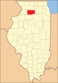
 Map of Illinois highlighting Lee County.svg 3,453 × 6,157; 85 KB


