Category:Maps of Llandudno
Jump to navigation
Jump to search
Media in category "Maps of Llandudno"
The following 12 files are in this category, out of 12 total.
-
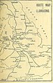 9 of 'Hartley's illustrated coaching guide to North Wales' (11199057046).jpg 1,271 × 1,978; 615 KB
-
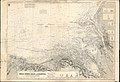
 Admiralty Chart No 1170A Holyhead to Great Ormes Head, Published 1873.jpg 16,143 × 10,891; 14.6 MB
-
 Admiralty Chart No 1170B Great Ormes Head to Liverpool, Published 1886, New Edition 1910.jpg 15,849 × 10,855; 50.05 MB
-
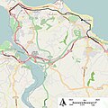
 Electoral wards in the town of Llandudno, North Wales.png 720 × 610; 54 KB
-
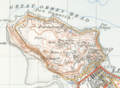 Great ormes headmap1947.png 1,556 × 1,144; 3.04 MB
-
 Information sign in Llandudno - geograph.org.uk - 3675346.jpg 1,024 × 757; 163 KB
-
 Llandudno and Colwyn Bay Electric Railway.jpg 600 × 600; 101 KB
-
 Llandudnomap1947.png 1,564 × 1,021; 3.64 MB
-
 Map Ffynhonnau.jpg 5,640 × 3,545; 2.19 MB
-
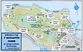
 Map yn dangos lleoliadau 13 o ffynhonnau ar Ben y Gogarth, Llandudno.jpg 2,594 × 1,578; 493 KB
-
 Ordnance Survey One-Inch Sheet 42 Llandudno & Denbigh, Published 1922.jpg 11,916 × 10,443; 12.53 MB
-
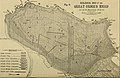 The Quarterly journal of the Geological Society of London (1898) (14592537128).jpg 3,456 × 2,234; 1.47 MB
.jpg)


_(14592537128).jpg)