Category:Maps of Massif du Mont-Blanc
Jump to navigation
Jump to search
Media in category "Maps of Massif du Mont-Blanc"
The following 24 files are in this category, out of 24 total.
-

-

-

-

-
-
 282 Martigny.jpg 14,000 × 9,600; 32.94 MB
-
 292 Courmayeur.jpg 14,000 × 9,600; 31.42 MB
-
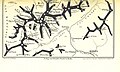
 535 of 'Le Mont-Blanc ... Illustré de 15 gravures, etc' (11119639596).jpg 4,024 × 2,783; 2.74 MB
-
 537 of 'Le Mont-Blanc ... Illustré de 15 gravures, etc' (11120385445).jpg 4,539 × 2,715; 3.33 MB
-
 Aiguille du Tour.png 686 × 559; 380 KB
-
 Chamonix and Mont-Blanc map 1892.jpg 3,535 × 5,071; 8.04 MB
-
 France & Colonies-1894-Massif du Mont-Blanc.jpg 4,632 × 5,040; 3.84 MB
-
 Französ.Westalpen,Isere,Rhone.png 846 × 859; 268 KB
-
 Karte Mont-Blanc-Gruppe.png 1,884 × 1,981; 1.8 MB
-
 Map of the mountains and glaciers which surround the valley of Chamonix, 1830.jpg 3,850 × 2,387; 2.18 MB
-

-
 Mont Blanc et Alpes adjacentes. Parigi, William Coxe, 1790.jpg 2,609 × 2,188; 2.4 MB
-
 Mont Blanc massif (east).jpg 3,000 × 2,250; 395 KB
-
 Mont Blanc massif (west).jpg 3,000 × 2,250; 442 KB
-
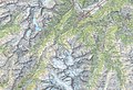
 Mont Blanc Relief Map, SRTM-1.jpg 1,600 × 1,200; 1.47 MB
-

-
 Sommet de plus de 4000m massif du Mont-Blanc.png 828 × 607; 1.03 MB
-
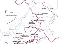
 Tour du Mont blanc Map.jpg 971 × 1,200; 346 KB
-
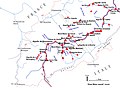
 Tour du Mont Blanc Static Map.png 600 × 751; 779 KB
)%27_(11007901803).jpg)
.jpg)
.jpg)
.jpg)
.jpg)


.jpg)
.jpg)


.jpg)
.jpg)

_(14584335527).jpg)


