Category:Maps of Norfolk County, Massachusetts
Jump to navigation
Jump to search
Counties of Massachusetts: Barnstable · Berkshire · Bristol · Dukes · Essex · Franklin · Hampden · Hampshire · Middlesex · Nantucket · Norfolk · Plymouth · Suffolk · Worcester
Wikimedia category | |||||
| Upload media | |||||
| Instance of | |||||
|---|---|---|---|---|---|
| Category combines topics | |||||
| Norfolk County | |||||
county in Massachusetts, United States     | |||||
| Instance of | |||||
| Named after | |||||
| Location | Massachusetts | ||||
| Capital | |||||
| Inception |
| ||||
| Population |
| ||||
| Area |
| ||||
| Different from | |||||
| official website | |||||
 | |||||
Subcategories
This category has the following 18 subcategories, out of 18 total.
A
D
F
M
N
Q
Media in category "Maps of Norfolk County, Massachusetts"
The following 29 files are in this category, out of 29 total.
-
 1858 Map of the county of Norfolk, Massachusetts.jpg 14,442 × 13,742; 28 MB
-
 1888 map of Walpole, East Walpole, South Walpole, and Plainville.jpg 13,329 × 8,481; 48.2 MB
-

-
 1904 Atlas of Massachusetts – Plate 15.png 4,130 × 2,879; 23.37 MB
-
 Braggville 1850-1880, Map of.svg 2,217 × 1,478; 688 KB
-
 Canton Viaduct map.svg 1,116 × 1,008; 545 KB
-

-
 Ma02 109.gif 636 × 379; 28 KB
-
 Ma03 109.gif 635 × 380; 37 KB
-
 Ma10 109.gif 636 × 379; 33 KB
-
 Map of Massachusetts highlighting Norfolk County.svg 2,976 × 1,819; 43 KB
-
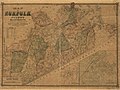
 Map of Norfolk County, Massachusetts (2675204720).jpg 2,000 × 1,457; 3.24 MB
-
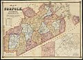
 Map of Norfolk County, Massachusetts LOC 2012592352.jpg 11,525 × 8,619; 16.83 MB
-
 Map of Norfolk County, Massachusetts LOC 2012592352.tif 11,525 × 8,619; 284.2 MB
-
 Map of the county of Norfolk, Massachusetts (2675203122).jpg 2,000 × 1,904; 3.7 MB
-
 Map of the town of Braintree, Norfolk County, Mass. LOC 2008624022.jpg 9,493 × 9,576; 11.64 MB
-
 Map of the town of Braintree, Norfolk County, Mass. LOC 2008624022.tif 9,493 × 9,576; 260.08 MB
-
 Map of the town of Canton, Norfolk County, Mass. (3855699027).jpg 1,594 × 2,000; 2.73 MB
-
 Map of the town of Medfield (2674728663).jpg 1,782 × 2,000; 3.21 MB
-
 Map of the town of Medway, Norfolk Co., Mass. (7537860566).jpg 2,000 × 1,342; 2.37 MB
-
 Map of the town of Needham, Mass. (4586562397).jpg 2,000 × 1,448; 2.1 MB
-
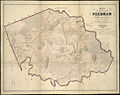 Map of the town of Needham, Norfolk County, Mass. (3856491054).jpg 2,000 × 1,580; 2.76 MB
-

-
 Map of the town of Walpole Norfolk County Mass. (3719858597).jpg 722 × 1,024; 582 KB
-
 Massachusetts location Norfolk.svg 500 × 314; 176 KB
-
 Norfolk county.png 500 × 306; 38 KB
-
 Plainville, Mass. (2673707367).jpg 2,000 × 1,361; 1.84 MB
-
-
 View of Medway, Massachusetts (2673677779).jpg 2,000 × 1,614; 2.84 MB


_Map_showing_drives_from_the_Walker-Gordon_Laboratory,_203_Claredon_St.,_Boston,_to_the_Laboratory_Farm_in_Wellesley,_Massachusetts,_by_Geo._H._Walker_%26_Co,_from_the_Digital_Commonwealth_-_commonwealth_wd376694j.jpg)


_(14595187080).jpg)


.jpg)

.jpg)

.jpg)
.jpg)
.jpg)
.jpg)
.jpg)
.jpg)
.jpg)


.jpg)
.jpg)
.jpg)