Category:Maps of Paris from Geographicus
Jump to navigation
Jump to search
Media in category "Maps of Paris from Geographicus"
The following 62 files are in this category, out of 62 total.
-
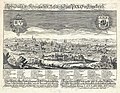 1650 Schnitzer view of Paris.jpg 4,000 × 3,116; 4.31 MB
-

-
-
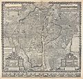
 1675 Rochefort Map of Paris.jpg 9,000 × 7,490; 24.9 MB
-
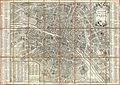
 1710 Jaillot Map of Paris.jpg 5,704 × 5,800; 10.8 MB
-

-

-

-
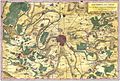 1780 Bonne Map of the Environs of Paris, France - Geographicus - Paris-bonne-1780 (2).jpg 3,783 × 2,567; 5.93 MB
-
 1780 Bonne Map of the Environs of Paris, France - Geographicus - Paris-bonne-1780.jpg 4,000 × 2,762; 2.09 MB
-
 1780 Esnauts and Rapilly Case Map of Paris - Geographicus - Paris-esnautsrapilly-1780.jpg 4,986 × 3,514; 12.57 MB
-
 1782 Esnauts and Rapilly Map of Paris.jpg 5,000 × 3,513; 7.61 MB
-
 1797 Jean Map of Paris and the Faubourgs, France - Geographicus - Paris-jean-1797.jpg 6,000 × 3,938; 9.78 MB
-

-
 1850 Andriveau-Goujon Map of Paris and Environs - Geographicus - Paris-goujon-1850.jpg 5,033 × 3,569; 10.25 MB
-

-

-

-
 1855 Colton Map or City Plan of Paris, France - Geographicus - Paris-c-55.jpg 3,000 × 2,451; 2.84 MB
-
 1857 Colton Map of Paris, France - Geographicus - Paris-cbl-1855.jpg 3,500 × 2,855; 2.92 MB
-

-
 1860 Andriveau Goujon Case Map of Paris, France - Geographicus - Paris-andriveau-1860.jpg 6,000 × 4,440; 8.98 MB
-

-
 1862 Vuillemin Map of Paris.jpg 8,500 × 6,699; 18.19 MB
-
 1863 Henriot Pocket Map of Paris, France - Geographicus - Paris-henriot-1863.jpg 6,000 × 4,166; 12.56 MB
-
 1864 Garnier Map of Pairs, France w-Monuments - Geographicus - Paris-garnier-1864.jpg 5,000 × 3,790; 5.93 MB
-

-
 1867 Fichot bird's eye view of Paris.jpg 9,000 × 6,132; 20.3 MB
-
 1867 Ledot Pocket Map of Paris, France - Geographicus - Paris-ledot-1867.jpg 6,000 × 4,110; 7.86 MB
-
 1867 Logerot Map of Paris, France - Geographicus - Paris-logerot-1867.jpg 6,000 × 4,652; 9.97 MB
-
 1870 Erhard Map of Paris and Vicinity, France - Geographicus - Paris-erhard-1870.jpg 4,000 × 3,084; 3.96 MB
-
 1870 Hachette Pocket Map of Paris, France - Geographicus - NouveauParis-hachette-1870.jpg 7,000 × 5,910; 10.41 MB
-
 1870 Vuillemin Map of Paris.jpg 8,000 × 6,811; 15.11 MB
-
 1877 Vuillemin Folding Pocket Map of Paris, France - Geographicus - Paris-vuillemin-1877.jpg 5,962 × 4,136; 8.85 MB
-
 1878 Andriveau-Goujon Pocket Map of Paris, France - Geographicus - Paris-andriveau-1878.jpg 6,000 × 4,532; 8.79 MB
-
 1878 Logerot Map of Paris, France - Geographicus - Paris-logerot-1878.jpg 6,000 × 4,099; 7.61 MB
-
 1878 Testard pictorial map of Paris with monuments.jpg 6,123 × 5,000; 14.15 MB
-
 1880 Clerot Pocket Map of Paris and Environs, France - Geographicus - Paris-clerot-1880.jpg 5,904 × 4,216; 16.09 MB
-
 1881 Lefevre Pocket Map or Plan of Paris, France - Geographicus - Paris-lefevre-1881.jpg 5,000 × 3,765; 6.34 MB
-
 1882 Andriveau-Goujon Pocket Map of Paris, France - Geographicus - Paris-andriveau-1882.jpg 6,000 × 4,570; 10.58 MB
-
-
 1889 Vuillemin Map of Paris, France - Geographicus - Paris-vuillemin-1889.jpg 6,000 × 4,173; 8.24 MB
-
 1892 Hachette Plan or Pocket Map of Paris, France - Geographicus - Paris-hachette-1892.jpg 6,000 × 5,037; 27.71 MB
-

-

-

-
 1902 L'Armee Case Map of Paris and Environs - Geographicus - Paris-armee-1902.jpg 6,000 × 5,078; 8.95 MB
-
 1910 Leconte Monument Map of Paris, France - Geographicus - ParisMonumental-leconte-1910.jpg 5,000 × 3,689; 5.94 MB
-

-
-
 1920 Robelin Map of Paris, France - Geographicus - Paris-robelin-1920.jpg 5,000 × 3,749; 14.88 MB
-

-

-
-

-

-

-

-

-

-
 Guilmin map of Paris, France, Monuments - Geographicus - Paris-Guilmin.jpg 5,000 × 3,680; 5.84 MB
-


_-_Geographicus_-_Paris-gomboust-1900.jpg)
_-_Geographicus_-_ParisSm-gomboust-1900.jpg)


_-_Geographicus_-_Paris-turgot-1900.jpg)
_-_Geographicus_-_Paris-turgot-1909.jpg)

.jpg)


_-_Geographicus_-_SeineEtOise-levasseur-1852.jpg)


_-_Geographicus_-_Paris-galignani-1865.jpg)


_-_Geographicus_-_Paris-hachette-1894.jpg)
_-_Geographicus_-_Paris-garnier-1900.jpg)
_-_Geographicus_-_NouveauParisMonumental-garnier-1900.jpg)


_-_Geographicus_-_Paris-leconte-1820.jpg)


.jpg)