<nowiki>Category:Maps of Veszprém County; categoría de Wikimedia; kategori Wikimedia; Wikimedia category; د ويکيمېډيا وېشنيزه; Vikimedya kategorisi; ویکیمیڈیا زمرہ; kategória projektov Wikimedia; категорія проєкту Вікімедіа; 维基媒体分类; Wikimedia-Kategorie; kategorie na projektech Wikimedia; kategorija na Wikimediji; विकिपीडिया:श्रेणी; page de catégorie de Wikimedia; kategorija na Wikimediji; विकिपीडिया वर्ग; категорија на Викимедији; Wikimedia-Kategorie; Wikimedia-kategori; kategori Wikimédia; تصنيف ويكيميديا; pajenn rummata eus Wikimedia; Wikimedia:ကဏ္ဍခွဲခြင်း; 維基媒體分類; Wikimedia категориясы; categoría de Wikimedia; Wikimedia-categorie; Викимедиа категорияһы; tudalen categori Wikimedia; Viciméid catagóir; ردهٔ ویکیپدیا; 维基媒体分类; Wikimedia-kategory; ვიკიპედია:კატეგორიზაცია; ウィキメディアのカテゴリ; categoria Wikimedia; تصنيف بتاع ويكيميديا; විකිමීඩියා ප්රභේද පිටුව; categoria Vicimediorum; Vikipidiya:Shopni; Wikimedia-luokka; Wikimedia-categorie; guruhi Vikimedia; катэгорыя ў праекце Вікімэдыя; Викимедиа проектындагы төркем; catigurìa di nu pruggettu Wikimedia; หน้าหมวดหมู่วิกิมีเดีย; Wikimedia:Kategorija; Wikimedia-Kategorie; Wikimedia:Klassys; категория на Уикимедия; categorie a unui proiect Wikimedia; categurìa 'e nu pruggette Wikimedia; Wikimedia-kategori; kawan Wikimèdia; гурӯҳи Викимедиа; 위키미디어 분류; Wikimedia-bólkur; kategorio en Vikimedio; kategori Wikimedia; categoría de Wikimedia; উইকিমিডিয়া বিষয়শ্রেণী; kategori Wikimedia; 维基媒体分类; וויקימעדיע קאַטעגאָריע; kategorija w projektach Wikimedije; thể loại Wikimedia; Wikimedia projekta kategorija; Wikimedia-kategorie; categoria de um projeto da Wikimedia; Wikimedia category; категорияд Ангилал; Wikimedia-kategori; kategori Wikimedia; پۆلی ویکیمیدیا; Wikimedia category; Vikimédia ñemohenda; Wikimédia-kategória; વિકિપીડિયા શ્રેણી; Wikimediako kategoria; категория в проекте Викимедиа; Wikimedia-Kategorie; катэгорыя ў праекце Вікімедыя; Wikimedia-kategorie; Wîkîmediya:Kategorî; विकिमिडिया श्रेणी; Wikimedia-Kategorie; קטגוריה במיזמי ויקימדיה; Викимедиа проектындагы төркем; κατηγορία εγχειρημάτων Wikimedia; विकिमिडिया श्रेणी; Wikimedia-Kategorie; Wikimedia-kategoriija; гурӯҳи Викимедиа; Wikimedia-categorie; Wikimedia:Ronnaghys; Wikimedia category; categoria di un progetto Wikimedia; விக்கிமீடியப் பகுப்பு; jamii ya Wikimedia; 维基媒体分类; Wikimedia kategooria; 維基媒體分類; Վիքիմեդիայի նախագծի կատեգորիա; kategorya ng Wikimedia; 維基媒體分類; ẹ̀ka Wikimedia; Викимедиина категорија; categoria de um projeto da Wikimedia; Wikimedia-Kategorie; Kategoriya ning Wikimedia; tumbung Wikimedia; kategoria ti Wikimedia; kategorija Wikimedije; Wikimedia proyektındağı törkem; categoria de Wikimedia; Wikimedia-Kategorie; kategori Wikimedia; kategoria w projekcie Wikimedia; വിക്കിമീഡിയ വർഗ്ഗം; 維基媒體分類; kategori Wikimedia; Wikimedia-kategori; زمرو:وڪيپيڊيا زمرا بندي; kategori e Wikimedias; categoría de Wikimedia; 維基媒體分類; 维基媒体分类; विकिमीडिया श्रेणी</nowiki>
Subcategories
This category has the following 3 subcategories, out of 3 total.

_3.jpg)


 Ajkai vörösiszap-katasztrófa vázlat 2010-10-04.svg 1,732 × 964; 309 KB
 Balaton-felvidéki Kéktúra pecsételőhely Salföld BFK 15.jpg 4,896 × 3,672; 8.82 MB
 Brook Tapolca.png 290 × 335; 22 KB
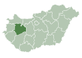 HU county Veszprem.svg 1,052 × 744; 172 KB
 Kékkúti Theodora Forrás - 2014.07.06 (3).JPG 4,320 × 3,240; 5.16 MB
 Map of the battleground of the Battle of Ihász (1849).jpg 3,850 × 2,850; 2.53 MB
 Map of Tihany Abbey. - I. András Square, Tihany.JPG 2,272 × 1,704; 944 KB
 Nemesvámos látványtérképe.jpg 1,000 × 500; 633 KB
 Subregion Ajka.PNG 806 × 506; 34 KB
 Subregion Sumeg.PNG 806 × 506; 34 KB
 Subregion Tapolca.PNG 806 × 506; 34 KB
 Sümeg BV043881263.jpg 14,406 × 11,102; 28.41 MB
 Veszprem county map.jpg 2,100 × 1,665; 485 KB
 VeszpremCounty.gif 301 × 198; 3 KB
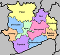 Veszprém districts.png 602 × 548; 37 KB
 Veszprém location map.PNG 2,678 × 2,568; 632 KB
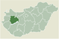 VeszprémMegye.png 1,123 × 748; 53 KB


.JPG)
.jpg)


