Category:Maps of municipalities in the canton of Lucerne to 2012
Jump to navigation
Jump to search
Subcategories
This category has only the following subcategory.
L
Media in category "Maps of municipalities in the canton of Lucerne to 2012"
The following 10 files are in this category, out of 10 total.
-
 Karte Bezirk Entlebuch 2007 blank.png 2,066 × 1,642; 629 KB
-
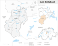 Karte Bezirk Entlebuch 2007.png 2,066 × 1,642; 779 KB
-
 Karte Bezirk Hochdorf 2009 blank.png 2,066 × 1,528; 630 KB
-
 Karte Bezirk Hochdorf 2009.png 2,066 × 1,528; 755 KB
-
 Karte Bezirk Luzern 2010 blank.png 2,066 × 1,419; 608 KB
-
 Karte Bezirk Luzern 2010.png 2,066 × 1,419; 731 KB
-
 Karte Bezirk Sursee 2009 blank.png 2,066 × 1,603; 666 KB
-
 Karte Bezirk Sursee 2009.png 2,066 × 1,603; 811 KB
-
 Karte Bezirk Willisau 2007 blank.png 2,066 × 1,568; 670 KB
-
 Karte Bezirk Willisau 2007.png 2,066 × 1,568; 806 KB


