Category:Maps of the Dutch East India Company - Australia
Jump to navigation
Jump to search
Media in category "Maps of the Dutch East India Company - Australia"
The following 17 files are in this category, out of 17 total.
-
 AMH-5135-NA Map of the Indies archipelago.jpg 2,400 × 1,694; 792 KB
-
 AMH-5191-NA Map of the Cape of Good Hope up to and including Japan.jpg 2,400 × 1,724; 787 KB
-
 AMH-5321-NA Map of Hollandia Nova.jpg 2,400 × 1,682; 661 KB
-
 AMH-5322-NA Map showing a portion of the northwest coast of Australia.jpg 2,400 × 1,688; 553 KB
-
 AMH-5324-NA Map showing a stretch of the Australian coast.jpg 2,400 × 1,680; 749 KB
-
 AMH-5325-NA Map showing a stretch of the Australian coast.jpg 1,698 × 2,400; 463 KB
-
 AMH-5326-NA Map showing a stretch of the Australian coast.jpg 2,400 × 1,685; 742 KB
-
 AMH-5327-NA Map showing a stretch of the Australian coast.jpg 2,400 × 1,693; 707 KB
-
 AMH-5328-NA Map showing a stretch of the Australian coast.jpg 1,699 × 2,400; 435 KB
-

-
 AMH-5544-NA Map of part of the coast of Australia.jpg 2,400 × 1,029; 471 KB
-
 AMH-5545-NA Map of part of Australia.jpg 2,400 × 1,468; 753 KB
-
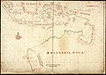
 AMH-6426-NA Map showing the coasts of New Guinea.jpg 2,400 × 1,416; 597 KB
-
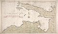
 AMH-6616-NA Map of the South Land, that is Australia.jpg 2,400 × 1,132; 406 KB
-
 AMH-7120-KB Map of Asia and Australia.jpg 2,400 × 2,092; 1.37 MB
-
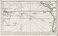
 AMH-7220-KB Map showing the route taken by Abel Tasman.jpg 2,400 × 1,580; 534 KB
-