Category:Maps of the Indian Ocean
Jump to navigation
Jump to search

Subcategories
This category has the following 19 subcategories, out of 19 total.
*
- Global maps centered 70E (2 F)
- Global maps centered 80E (2 F)
A
C
- Maps of the Crozet Islands (25 F)
G
I
M
S
T
W
Media in category "Maps of the Indian Ocean"
The following 70 files are in this category, out of 70 total.
-
 Op Banquet.jpg 1,020 × 730; 126 KB
-
 2020 JTWC WTXS21 forecast map.sh9521.gif 1,827 × 1,016; 42 KB
-
 85E Ridge FreeAir.png 2,095 × 3,159; 1.18 MB
-
 Aabwpathways.svg 3,509 × 2,480; 2.05 MB
-
 Admiralty Chart Catalogue 1967 Page 048 Index H.jpg 8,594 × 6,897; 7.91 MB
-
 Admiralty Chart No 2899 Chagos Archipelago to Madagascar, Published 1963, Large Corrections 1965.jpg 16,238 × 11,073; 34.8 MB
-
 Admiralty Chart No 2900 Ceylon to Madagascar, Published 1963, Large Corrections 1965.jpg 16,303 × 11,096; 38.58 MB
-
 Agulhas Bank NOAA ETOPO1.jpg 703 × 417; 91 KB
-
 Agulhas Bank NOAA.jpg 1,010 × 682; 88 KB
-
 Agulhas Basin NOAA.jpg 730 × 617; 82 KB
-
 APWPGP Illustration.png 626 × 630; 147 KB
-
 Atoll research bulletin (1967) (20159131359).jpg 1,932 × 1,634; 662 KB
-
 Atoll research bulletin (1969) (20337430862).jpg 2,848 × 2,274; 872 KB
-
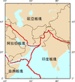 Bajisitan-bankuai-zh-tw.png 244 × 266; 16 KB
-
 Bajisitan-bankuai-zh.png 244 × 266; 15 KB
-
 Bay of Bengal map pl.svg 1,662 × 1,646; 508 KB
-
 Bay of Galle and environ.png 3,223 × 2,319; 311 KB
-
 Belem - Discoveries Monument P1000151.JPG 4,000 × 3,000; 4.77 MB
-
 Collardeperlaschino.png 1,481 × 685; 258 KB
-
 Diamantinapstoedit.svg 864 × 756; 282 KB
-
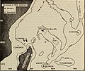
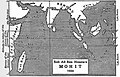 EB1911 - Globe - Fig. 18. —The Indian Ocean according to MohitMohit.jpg 1,059 × 676; 406 KB
-
 India-Oceanic-Crustal-Map-with legend.jpg 450 × 450; 186 KB
-
 India-Oceanic-Crustal-Map.jpg 250 × 232; 80 KB
-
 Indiako ozeanoa.png 330 × 330; 35 KB
-
 Indian Ocean Gyre.png 681 × 624; 329 KB
-
 Indian Ocean in the world (blue) (W3) (CWF).svg 3,936 × 2,405; 4.76 MB
-
 Indian Ocean surface.jpg 982 × 958; 260 KB
-
 Indian Ocean.png 488 × 487; 22 KB
-
 Indianocéanie - ZEE.png 710 × 612; 112 KB
-
 Indo-Pacific biogeographic region map-eu.svg 1,950 × 1,200; 1.48 MB
-
 Location map of the Offshore Indus Basin, Pakistan.jpg 572 × 904; 152 KB
-
 LocationIndianOcean.png 2,760 × 1,398; 91 KB
-
 M 6.5 - southeast Indian Ridge.jpg 214 × 240; 4 KB
-
 Map of ocean floor based on earths gravity field.png 1,500 × 1,079; 3.51 MB
-
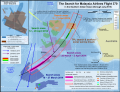
 Map of satellite images of possible debris from MH370.png 870 × 822; 31 KB
-
 Map of the North West Indian Ocean by Gholamali Bayandor.jpg 916 × 564; 122 KB
-
 Map of the Sumatra Trench.jpg 946 × 549; 638 KB
-
 Map of the Territorial Waters of the Atlantic and Indian Ocean.png 2,919 × 1,676; 588 KB
-
 MeanWaveHeight1992.png 402 × 257; 97 KB
-
 Mengjiala-wan-zh.png 1,000 × 1,019; 264 KB
-
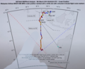
 MH370 SIO search.png 7,461 × 5,720; 8.68 MB
-
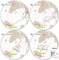
 MH370 suspect hydroacoustic detection.svg 3,900 × 2,963; 1.39 MB
-
 Mh370-laptop-cut-retusche-overlay.png 1,096 × 887; 499 KB
-
 Milky sea.jpg 403 × 403; 64 KB
-
 Mizrah Tikhon Hadhash.jpg 407 × 203; 17 KB
-
 NASA's Aquarius Sees Salty Shifts (8512914945).jpg 5,760 × 3,240; 2.78 MB
-
 Oceano Indiano.PNG 330 × 330; 14 KB
-
 Operation Samudra Setu map.jpg 700 × 400; 123 KB
-

-
 Orthographic Projection 30W 150E.png 437 × 434; 11 KB
-
 Orthographic projection centred over Diego Garcia.png 488 × 487; 32 KB
-
 Orthographic projection centred over Ile Amsterdam.png 488 × 487; 37 KB
-
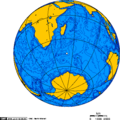 Orthographic projection centred over the Iles Crozet.png 488 × 487; 21 KB
-
 Orthographic projection over Diego Garcia.png 488 × 487; 19 KB
-
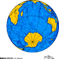 Orthographic projection over the Heard Islands.png 488 × 487; 21 KB
-
 PAT - Indian Ocean.gif 1,700 × 1,800; 505 KB
-
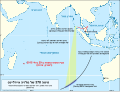 Reunion debris compared to MH370 flight path and underwater search area (he).svg 3,900 × 2,963; 1.63 MB
-
-
 Reunion debris compared to MH370 flight path and underwater search area.svg 3,900 × 2,963; 1.39 MB
-
 Reunion debris compared to MH370 flight paths and underwater search area.png 6,067 × 4,608; 2.07 MB
-

-
-
-
-

-
 SeaStateForecast.png 660 × 584; 75 KB
-
 SMOS2010.png 1,418 × 598; 1,009 KB
-
 Stamp of Seychelles - 1956 - Colnect 307271 - Map.jpeg 500 × 417; 78 KB
-
 Xo-map.png 330 × 330; 11 KB
-
 郑和下西洋路线图.png 506 × 236; 61 KB


_(20159131359).jpg)
_(20337430862).jpg)


_(W3)_(CWF).svg)


.jpg)


.jpg)


.svg)


.jpg)
.jpg)
.jpg)
.jpg)
.jpg)


