Category:Maps of the province of Ferrara
Jump to navigation
Jump to search
Italiano: Mappe della provincia di Ferrara.
Subcategories
This category has the following 3 subcategories, out of 3 total.
C
F
Media in category "Maps of the province of Ferrara"
The following 15 files are in this category, out of 15 total.
-
 Delta-Pô-1603.jpg 537 × 733; 114 KB
-
 Atlas Van der Hagen-KW1049B12 073-DVCATO DI FERRARA.jpeg 5,500 × 4,315; 3.82 MB
-
 Ducato di Ferrara (8342170795) (cropped).jpg 926 × 1,234; 1.47 MB
-
 Ducato di Ferrara (8342170795).jpg 6,684 × 5,571; 36.06 MB
-
 Ferrara particolare Sala delle Geografie o Marchesana, Castello Estense 0.jpg 5,139 × 2,986; 3.8 MB
-
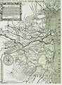
 Nuova raccolta d'autori, che trattano del moto dell'acque (1766) (14773966674).jpg 3,584 × 2,115; 1.41 MB
-
 Padusa-1778.JPG 944 × 658; 154 KB
-
 Delta-Pô-1787.jpg 750 × 561; 87 KB
-
 Vallardi - Ferrara.jpg 6,188 × 4,168; 9.2 MB
-
 Ferrara in Italy.svg 1,034 × 1,299; 3 MB
-
 Ferrara posizione.png 350 × 424; 14 KB
-
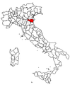
 Italy.Emilia Romagna.Ferrara.Position.png 182 × 152; 4 KB
-
 Map Province of Ferrara.svg 1,200 × 1,500; 1,011 KB
-
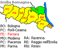
 Mappa dell'AUSL di Ferrara.svg 5,454 × 2,900; 77 KB
-
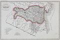
 Vallardi - Provincie Rovigo e Ferrara.jpg 6,101 × 4,441; 11.78 MB


_(cropped).jpg)
.jpg)

_(14773966674).jpg)


