Category:Maps showing 1800
Jump to navigation
Jump to search
| ← 1800 1801 1802 1803 1804 1805 1806 1807 1808 1809→ |
English: Maps showing the year 1800 (i.e. history maps)
See also category: 1800 maps. and 1800s maps for old maps created in this time.
See also category: 1800 maps. and 1800s maps for old maps created in this time.
Subcategories
This category has only the following subcategory.
Media in category "Maps showing 1800"
The following 9 files are in this category, out of 9 total.
-
 Black Americans 1800 County.png 10,218 × 8,500; 3.63 MB
-
 Brunei territories (1800).jpg 1,920 × 960; 402 KB
-
 Brunei territories (1800).png 1,920 × 960; 289 KB
-

-
 Map of the Pashalik of Belgrade 1800.jpg 2,393 × 1,296; 365 KB
-
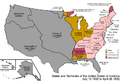
 United States 1798-1800-07-04.png 1,000 × 677; 103 KB
-
 United States 1800-07-04-1800-07-10.png 1,000 × 677; 104 KB
-
 United States 1800-07-10-1802.png 1,000 × 677; 102 KB
-
 White Americans 1800 County.png 10,218 × 8,500; 3.57 MB

.jpg)
.png)
.jpg)


