Category:Maps with Hölzel projection
Jump to navigation
Jump to search
English: Maps with Hölzel projection (Hoelzel projection):
- Longitudes: sinusoid
- Latitudes: strait, equal spaced
- Global outer curve: semi sinusoids, near the poles ellipsoids, poles cropped to straight
English: This map-projection-related category exists in the following hierarchy:
- Category:Map projections
- Category:Maps by projection
- Category:Hölzel projection – media related to the Hölzel projection other than maps
- Category:Maps with Hölzel projection (“Category:Hölzel projections”) – maps made using the Hölzel projection
| NO WIKIDATA ID FOUND! Search for Maps with Hölzel projection on Wikidata | |
| Upload media |
Media in category "Maps with Hölzel projection"
The following 7 files are in this category, out of 7 total.
-
 ErdebeiNacht2Hölzel.png 1,878 × 940; 1.1 MB
-
 Hdi2011.png 2,804 × 1,766; 135 KB
-
 Hdi2011colorsave.png 2,804 × 1,766; 134 KB
-
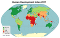
 Hdi2011eng.png 2,804 × 1,766; 136 KB
-
 Hoelzel10ost.jpg 10,800 × 6,123; 5.84 MB
-
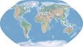
 Hoelzelbluemarble.png 2,058 × 1,034; 1.56 MB
-
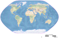 Hoelzelnaturalearth.png 3,038 × 1,944; 6.66 MB


